Filter: Categories of Wisconsin Historical Images
Filter: County of Pierce
Filter: Type of Map or Atlas
Filter: Categories of Wisconsin Historical Images
Filter: County of Pierce
Filter: Type of Map or Atlas
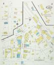
| Date: | 08 1927 |
|---|---|
| Description: | Sanborn map of Ellsworth, Wisconsin. |

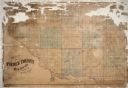
| Date: | 1922 |
|---|---|
| Description: | This map of Pierce County, Wisconsin, from the first half of the 20th century, shows the township and range grid, towns, sections, villages, roads, railroa... |

| Date: | 1882 |
|---|---|
| Description: | This map is ink and watercolor on paper and shows numbered plots, the public square, streets, Lake St. Croix and the Mississippi River. |

| Date: | 1884 |
|---|---|
| Description: | Page one of a Sanborn map of River Falls, Wisconsin. |
If you didn't find the material you searched for, our Library Reference Staff can help.
Call our reference desk at 608-264-6535 or email us at: