Filter: Categories of Wisconsin Historical Images
Filter: County of Pierce
Filter: Subject of human settlements
Filter: Categories of Wisconsin Historical Images
Filter: County of Pierce
Filter: Subject of human settlements

| Date: | 1930 |
|---|---|
| Description: | Exterior view of the childhood home of John M. Callahan, State Superintendent of Schools. |
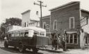
| Date: | 1925 |
|---|---|
| Description: | A passenger bus making a stop at the service station of Gustav H. Schwalen. |

| Date: | |
|---|---|
| Description: | Elevated view looking down towards a steamboat pulling a raft of lumber on the Mississippi River. Caption reads: "Mississippi River at Prescott, Wis." |
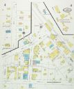
| Date: | 08 1927 |
|---|---|
| Description: | Sanborn map of Ellsworth, Wisconsin. |

| Date: | 1911 |
|---|---|
| Description: | A college student setting out to class in zero degree weather. He is holding his books, and is wearing a hat and gloves, and has a scarf wrapped around his... |
| Date: | 2008 |
|---|---|
| Description: | Knute Bjornson originally built this house in the 1860's and in 1933, his grandson Cooney Bjornson reassembled the humble log building to house a gas stati... |

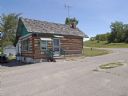
| Date: | 1900 |
|---|---|
| Description: | A view of the row of shops along Main Street, with J.W. Allard's store in the foreground on the right. A group of men are further down the street. |

| Date: | 1927 |
|---|---|
| Description: | A view of the vine-covered facade and side of North Hall at the State Normal School. Stone work decorates the top of the building and a flag flies from the... |

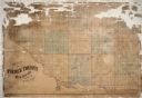
| Date: | 1922 |
|---|---|
| Description: | This map of Pierce County, Wisconsin, from the first half of the 20th century, shows the township and range grid, towns, sections, villages, roads, railroa... |

| Date: | |
|---|---|
| Description: | Photographic postcard view of a street in a rural community's central business district. A biplane, printed into the background, is flying low overhead. A ... |
| Date: | 1893 |
|---|---|
| Description: | Valley view of town buildings and hillside. |

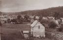
| Date: | 1882 |
|---|---|
| Description: | This map is ink and watercolor on paper and shows numbered plots, the public square, streets, Lake St. Croix and the Mississippi River. |
| Date: | 1910 |
|---|---|
| Description: | Black and white photographic postcard view across water towards three steamboats on the shoreline of the Mississippi River. |

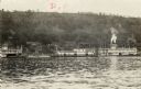
| Date: | |
|---|---|
| Description: | Exterior view of the First Congregational Church, with bell tower. Snow is on the ground. |
| Date: | 06 09 1955 |
|---|---|
| Description: | Exterior of church, with cemetery and steeple visible. A sign identifying it as Rush River Luth[eran] hangs over the door. Cars are parked outside the chur... |

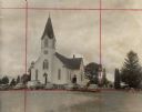
| Date: | 1908 |
|---|---|
| Description: | A view of two roads. The road on the left is heading downhill and has a sidewalk along it on the left and buildings in the distance. The other road is wind... |

| Date: | 1884 |
|---|---|
| Description: | Page one of a Sanborn map of River Falls, Wisconsin. |

| Date: | 10 11 1948 |
|---|---|
| Description: | Text on front reads: "Main Street, River Falls, Wis." Main street with a parking boulevard in the center, filled with automobiles. Several people are out a... |
If you didn't find the material you searched for, our Library Reference Staff can help.
Call our reference desk at 608-264-6535 or email us at: