 Filter: Categories of Wisconsin Historical Images
Filter: County of Portage
Filter: Subject of cities and towns
Filter: Subject of aerial photographs
Filter: Categories of Wisconsin Historical Images
Filter: County of Portage
Filter: Subject of cities and towns
Filter: Subject of aerial photographs

| Date: | 1965 |
|---|---|
| Description: | Aerial view of town and Highway 66. |
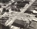
| Date: | 1955 |
|---|---|
| Description: | Aerial view of town, with commercial buildings, and cars in parking lots. |

| Date: | 1965 |
|---|---|
| Description: | Aerial view that encompasses most of the town and part of the Wisconsin River. |
| Date: | 1965 |
|---|---|
| Description: | Aerial view, looking west, with potato warehouses in the foreground and a pallet factory and junkyard behind them at right. |

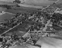
| Date: | 1965 |
|---|---|
| Description: | Aerial view looking north-northwest. View includes houses, roads, farm buildings, tractor-trailors (parked), other buildings. |
If you didn't find the material you searched for, our Library Reference Staff can help.
Call our reference desk at 608-264-6535 or email us at:
