 Filter: Categories of Wisconsin Historical Images
Filter: County of Portage
Filter: Subject of cities and towns
Filter: Subject of food industry and trade
Filter: Categories of Wisconsin Historical Images
Filter: County of Portage
Filter: Subject of cities and towns
Filter: Subject of food industry and trade
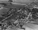
| Date: | 1965 |
|---|---|
| Description: | Aerial view, looking west, with potato warehouses in the foreground and a pallet factory and junkyard behind them at right. |
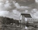
| Date: | 1950 |
|---|---|
| Description: | Grist mill. Two people with bicycles on bridge near mill. |
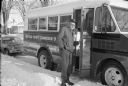
| Date: | 01 1979 |
|---|---|
| Description: | Bus operated by the Portage County Commission on Aging and its driver. The bus took senior citizens to lunch at the Senior Center and provided other servic... |

| Date: | |
|---|---|
| Description: | This map from the early 20th century shows the township and range grid, towns, sections, cities and villages, railroads, roads, schools, churches, cemeteri... |
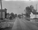
| Date: | 1926 |
|---|---|
| Description: | View of Main Street with puddles along the side of the street. Trucks and automobiles are traveling down the street, and are parked on the left. A restaura... |
| Date: | 06 1986 |
|---|---|
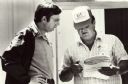
| Description: | Jerry Zarecki (in the hat), president of the Portage County Farmers Union, presents Wisconsin Congressman David R. Obey with one folder of petitions collec... |

| Date: | 1891 |
|---|---|
| Description: | The index page of a Sanborn Map of Stevens Point. |

| Date: | 1891 |
|---|---|
| Description: | Page 13 of a Sanborn map of Stevens Point. |
If you didn't find the material you searched for, our Library Reference Staff can help.
Call our reference desk at 608-264-6535 or email us at: