 Filter: Categories of Wisconsin Historical Images
Filter: County of Portage
Filter: Subject of cities and towns
Filter: Subject of wisconsin river (wis.)
Filter: Categories of Wisconsin Historical Images
Filter: County of Portage
Filter: Subject of cities and towns
Filter: Subject of wisconsin river (wis.)
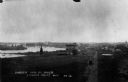
| Date: | 1898 |
|---|---|
| Description: | Elevated view of the Jackson Milling Company, the Green Bay railroad tracks, and the Wisconsin Central railroad tracks. Caption reads: "Birdseye View of Ri... |
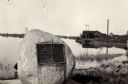
| Date: | 1925 |
|---|---|
| Description: | View of the Stevens monument, erected in honor of George Stevens, whom the town is named after, at the site where he landed in 1824. |

| Date: | 1910 |
|---|---|
| Description: | View across grass towards a wagon bridge on the left crossing the Wisconsin River at Stevens Point. Caption reads: "Wagon Bridge, across Wisconsin River, S... |

| Date: | 1965 |
|---|---|
| Description: | Aerial view that encompasses most of the town and part of the Wisconsin River. |

| Date: | |
|---|---|
| Description: | Exterior of the Consolidated Water Power and Paper Company, built in 1918. The view from across the Wisconsin River shows the company building, a dam, as w... |

| Date: | |
|---|---|
| Description: | View taken from the Paper Mill Road toward the Wisconsin River Pulp and Paper Company paper mill. On the bank in the foreground are small boats. The paper ... |

| Date: | 1910 |
|---|---|
| Description: | This map of Stevens Point shows the Wisconsin River, labeled plat additions, numbered lots, and some land ownership. An inset map in the bottom left corner... |

| Date: | 1986 |
|---|---|
| Description: | Pictorial map showing businesses with phone numbers, roads, railroads, and parks. Includes text titled: "History of Portage County." |

| Date: | 1950 |
|---|---|
| Description: | This blueline print shows roads and proposed roads in parts of the Towns of Carson, Hull, Linwood, and Plover, as well as boundaries and lines demarking ex... |

| Date: | 05 16 1994 |
|---|---|
| Description: | The front side of this map shows roads, highways, the Wisconsin River, Stevens Point Airport, and surrounding towns. A street index is included along the r... |

| Date: | 07 20 1931 |
|---|---|
| Description: | Text on front reads: "Clark Street Bridge, Stevens Point, Wis." View from shoreline towards a bridge built of stone, with lampposts, spanning the Wisconsin... |

| Date: | 1891 |
|---|---|
| Description: | The index page of a Sanborn Map of Stevens Point. |
If you didn't find the material you searched for, our Library Reference Staff can help.
Call our reference desk at 608-264-6535 or email us at: