 Filter: Categories of Wisconsin Historical Images
Filter: County of Price
Filter: Reproduction Rights of For Sale
Filter: Subject of transportation
Filter: Categories of Wisconsin Historical Images
Filter: County of Price
Filter: Reproduction Rights of For Sale
Filter: Subject of transportation
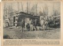
| Date: | 1895 |
|---|---|
| Description: | A promotional card advertising farming land in northern Wisconsin. The image depicts four settler men, their two horses, and their dog outside a temporary ... |
| Date: | 07 1897 |
|---|---|
| Description: | A promotional card displaying a man in overalls standing by his large rye crops, near the road. The caption reads, "This view made from a photograph take... |

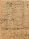
| Date: | 1887 |
|---|---|
| Description: | This 1887 map of Price County, Wisconsin, shows the township and range system, sections, railroads, vacant land and land sold by the Wisconsin Central Rail... |

| Date: | 1914 |
|---|---|
| Description: | This map of Price County, Wisconsin, from the early 20th century shows land for sale by the Homemaker Land Company of Milwaukee. The township and range sys... |

| Date: | 1925 |
|---|---|
| Description: | This map of Price County, Wisconsin, from the early 20th century shows the township and range system, towns, sections, cities and villages, railroads, high... |

| Date: | 1888 |
|---|---|
| Description: | This late 19th century map of Price County, Wisconsin, shows landownership and waterfront acreages, the township and range system, towns, cities and villag... |
| Date: | |
|---|---|
| Description: | This map of Price County shows roads, railroads, schools, churches, and cemeteries. Townships are labelled, as well as some points of interest. There appea... |

| Date: | 1910 |
|---|---|
| Description: | This map from the early 20th century shows the Wisconsin Central Railroad land grant lands owned and for sale by the Soo Line in Price County, Wisconsin, a... |

| Date: | 1914 |
|---|---|
| Description: | This 1914 map of Price County, Wisconsin, shows land for sale by the Good Land Company and Dewitt van Ostrand of Phillips. Also shown are the township and ... |

| Date: | 1925 |
|---|---|
| Description: | This map of Price County, Wisconsin, from the early 20th century shows the township and range system, towns, sections, cities and villages, railroads, high... |

| Date: | 1986 |
|---|---|
| Description: | This late 1980s map of Price County, Wisconsin, shows facilities and lands open for public recreation, hunter walking trails and ski trails, campgrounds, b... |

| Date: | 1910 |
|---|---|
| Description: | This map is ink on paper. Shows Bruce’s proposed railway route and Moon’s railroad survey route along the Flambeau River, in parts of Lake and Eisenstein t... |

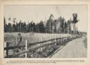
| Date: | 1926 |
|---|---|
| Description: | View down center of railroad tracks towards the Prentice Depot and railroad crossing. A man is walking on the platform of the depot. On the left in the bac... |

| Date: | 1926 |
|---|---|
| Description: | View across yard of the co-operative Creamery Company. There are two large vents on the roof of the building that have weather vanes decorated with cows. |

| Date: | |
|---|---|
| Description: | Postcard advertising the Good Land Company with a photograph of a farm and information for "Homeseekers, Farmers and Investors." |

| Date: | 1903 |
|---|---|
| Description: | This blue line print map is oriented with the north to the left and shows buildings with dimensions, utilities, and proposed buildings. The Flambeau River ... |

| Date: | 1891 |
|---|---|
| Description: | This map shows vacant Southwick & Sellers lands, settlers' houses, Goodland Co. land, schools, churches, saw mills, roads, and railroads. A key in the uppe... |

| Date: | 11 1923 |
|---|---|
| Description: | This map shows buildings, lots, utilities, and original plat and present locations of railroads. Portions of the map are shown in red, brown, yellow, blue,... |
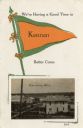
| Date: | |
|---|---|
| Description: | An illustration of a pennant, and a photograph of the town. |

| Date: | 07 1936 |
|---|---|
| Description: | Stacks of logs cover a large flat area in the foreground, and in the distance is a complex of buildings at a sawmill. There are many large stacks of lumber... |
If you didn't find the material you searched for, our Library Reference Staff can help.
Call our reference desk at 608-264-6535 or email us at: