 Filter: Categories of Wisconsin Historical Images
Filter: County of Price
Filter: Subject of human settlements
Filter: Categories of Wisconsin Historical Images
Filter: County of Price
Filter: Subject of human settlements
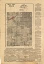
| Date: | 1935 |
|---|---|
| Description: | This map shows land zoning. The top middle includes a key of land zones, forestry, recreation, and unrestricted. The map includes extensive text on zoning ... |
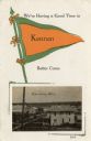
| Date: | |
|---|---|
| Description: | An illustration of a pennant, and a photograph of the town. |
| Date: | 1950 |
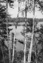
|---|---|
| Description: | Elevated view of a man fishing in a rowboat seen through a stand of Birch trees on Miles Lake. |
If you didn't find the material you searched for, our Library Reference Staff can help.
Call our reference desk at 608-264-6535 or email us at: