Filter: Categories of Wisconsin Historical Images
Filter: County of Shawano
Filter: Subject of human settlements
Filter: Type of Map or Atlas
Filter: Categories of Wisconsin Historical Images
Filter: County of Shawano
Filter: Subject of human settlements
Filter: Type of Map or Atlas

| Date: | 1920 |
|---|---|
| Description: | This map shows the township and range system, sections, schools, churches, cemeteries, town halls, roads, railroads, and lakes and streams in Shawano Count... |

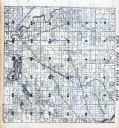
| Date: | 1933 |
|---|---|
| Description: | This map shows the township and range system, sections, cities and villages, schools, roads, railroads, and lakes and streams in Shawano County, which at t... |
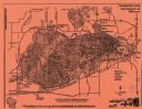
| Date: | 1991 |
|---|---|
| Description: | A map of Shawano Lake. Lake depths are shown by isolines. "Not intended for navigation." It includes a location map and a list of fish. |

| Date: | 1900 |
|---|---|
| Description: | Shows lands belonging to Wisconsin Timber and Land Co., towns, post offices, saw mills, creameries, camps, churches, schools, farm houses, town halls, rail... |

| Date: | 1834 |
|---|---|
| Description: | This map is pen, ink, and pencil on paper and shows plat of the town, local streets, mills, forts, hospitals, and parts of Devil River and Fox River. |

| Date: | 1975 |
|---|---|
| Description: | This map shows streets, railroads, and Wolf Lake. An index of streets is also included. |

| Date: | 1948 |
|---|---|
| Description: | This blue line print map shows lot and block numbers and dimensions, buildings, streets, railroads, and the Wolf River. |
If you didn't find the material you searched for, our Library Reference Staff can help.
Call our reference desk at 608-264-6535 or email us at: