 Filter: Categories of Wisconsin Historical Images
Filter: County of Trempealeau
Filter: Subject of cemeteries
Filter: Categories of Wisconsin Historical Images
Filter: County of Trempealeau
Filter: Subject of cemeteries
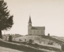
| Date: | 1945 |
|---|---|
| Description: | View of a rural church on a hill and its adjacent cemetery. Beaver Creek Lutheran Church was or still is a Norwegian church. |

| Date: | 1929 |
|---|---|
| Description: | This 1929 topographic map of Trempealeau County, Wisconsin, shows the topography, lakes, streams and wetlands, township and range grid, sections, cities an... |

| Date: | 1955 |
|---|---|
| Description: | This blue line print shows streets, fair grounds, schools, parks, and a cemetery. Streets, points of interest, and Lake Marinuka are labeled. The middle le... |
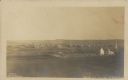
| Date: | 1910 |
|---|---|
| Description: | Text on front reads: "Bird's Eye View of Strum, Wis." Elevated view of a small town with hills on the horizon. A church and cemetery can be seen on the rig... |
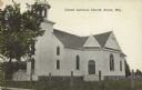
| Date: | 1907 |
|---|---|
| Description: | Text on front reads: "United Lutheran Church. Strum, Wis." A clapboard church with gable decorations and a belfry. A fence surrounds the church with a ceme... |

| Date: | 12 22 1906 |
|---|---|
| Description: | Text on front reads: "German Luth. Church near Whitehall, Wis." The church building on the right is surrounded by a farm, trees, fields and fences. |
If you didn't find the material you searched for, our Library Reference Staff can help.
Call our reference desk at 608-264-6535 or email us at: