 Filter: Categories of Wisconsin Historical Images
Filter: County of Vernon
Filter: Subject of human settlements
Filter: Categories of Wisconsin Historical Images
Filter: County of Vernon
Filter: Subject of human settlements
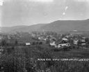
| Date: | 1925 |
|---|---|
| Description: | View of Coon Valley. Tall plants cover the lower portion of the frame. The landscape is includes homes, fields, and hills. |

| Date: | 1925 |
|---|---|
| Description: | View of a church, field, and cemetery from a hilltop. A car drives down the road in the lower-right corner. |
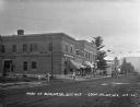
| Date: | 1922 |
|---|---|
| Description: | View across street of children on the sidewalk outside the Coon Valley State Bank. At the end of the street, there is an automotive repair station. |
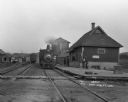
| Date: | 1912 |
|---|---|
| Description: | Train at Coon Valley depot. Several men stand on the platform. The depot has a water tank. There are advertisements for Pearl White Soap, the inter-state f... |

| Date: | 1912 |
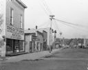
|---|---|
| Description: | View from across the intersection of Coon Valley State Bank, D.O. Stevlingson - the Gotzian Shoe, and the Restaurant Colonial. A horse and buggy is tied at... |
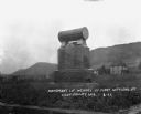
| Date: | 1922 |
|---|---|
| Description: | Monument dedicated to the first settlers of Coon Valley. The monument is in Norwegian. There is a cemetery in the distance. |
| Date: | 1922 |
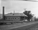
|---|---|
| Description: | Exterior view across road of a creamery. The front of the creamery has a roof supported with columns over the elevated driveway and loading dock for delive... |
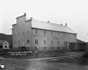
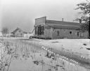
| Date: | |
|---|---|
| Description: | M.H. Bekkedale and E. Rosenwald and Brothers Leaf Tobacco warehouse. There is a boxcar on tracks near the warehouse, and a bluff in the far background. |
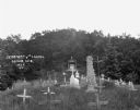
| Date: | 1922 |
|---|---|
| Description: | Tombstones at the cemetery, Looking up towards the chapel. |
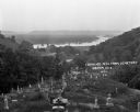
| Date: | 1922 |
|---|---|
| Description: | View from the hilltop at the Genoa cemetery looking down towards the village, the Mississippi River and the Minnesota border. |

| Date: | 1925 |
|---|---|
| Description: | Commercial street in Hillsboro. A row of cars are parked in the center of the street. |

| Date: | 1913 |
|---|---|
| Description: | Exterior of the Farmers State Bank building. The two-story brick building features the words "Farmers State Bank" on the facade as well as on the window. |

| Date: | |
|---|---|
| Description: | Exterior of the two-story Hansberry Hospital, where three cars and a motorcycle are parked in the adjacent lot. |
| Date: | 1909 |
|---|---|
| Description: | View down a street in La Farge. A store's sign reads, "Going out of Business - Entire stock and fixtures must be sold at a big discount." Other shops inclu... |
| Date: | 1914 |
|---|---|
| Description: | Exterior of the Farmers' Alliance Store. On the side of the building are two signs that say: "Horseshoe Tobacco." |
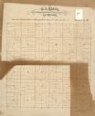
| Date: | |
|---|---|
| Description: | This 19th century manuscript map of the Town of Viroqua, Vernon County, Wisconsin, is drawn on a printed township grid. It shows landownership, roads, and ... |
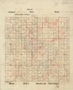
| Date: | |
|---|---|
| Description: | This 20th century manuscript map, drawn on a printed township grid and copied from an 1878 map, shows landownership and acreages, roads, and streams in the... |
If you didn't find the material you searched for, our Library Reference Staff can help.
Call our reference desk at 608-264-6535 or email us at:


