 Filter: Categories of Wisconsin Historical Images
Filter: County of Waukesha
Filter: Subject of cemeteries
Filter: Categories of Wisconsin Historical Images
Filter: County of Waukesha
Filter: Subject of cemeteries

| Date: | 1975 |
|---|---|
| Description: | A veteran places a flower on the grave of an unknown soldier. |
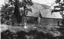
| Date: | 1900 |
|---|---|
| Description: | View of St. John Chrysostom Episcopal Church from the southwest. |
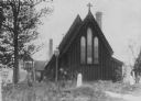
| Date: | 1900 |
|---|---|
| Description: | View of St. John Chrysostom Episcopal Church from the northeast. |
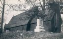
| Date: | 1900 |
|---|---|
| Description: | View of St. John Chrysostom Church and the surrounding cemetery. |
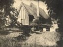
| Date: | 1900 |
|---|---|
| Description: | View of St. John Chrysostom Church and the surrounding cemetery, with a woman standing near the church's right side. |
| Date: | |
|---|---|
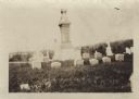
| Description: | Ten graves of the Hedjord family in the Muskego churchyard. There is an obelisk is the center of graves. |
| Date: | |
|---|---|
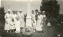
| Description: | Outdoor group portrait of women and one child alongside the graves of Colonel Hans Heg, commander of the 15th Wisconsin Infantry, and his daughter Annetta.... |

| Date: | 1887 |
|---|---|
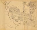
| Description: | This late 19th century map shows the lake region around Oconomowoc in Waukesha County and eastern Jefferson County, Wisconsin. Cities and villages, roads, ... |
| Date: | 1870 |
|---|---|
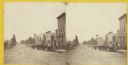
| Description: | Stereograph view of Oconomowoc. |

| Date: | 1965 |
|---|---|
| Description: | This basic street map shows roads, schools, parks and cemeteries and includes a street index in the lower margin. The map also shows a portion of Elm Grove... |
| Date: | |
|---|---|
| Description: | This map is a photocopy and shows the Oconomowoc River, Flower Lake, lot and block numbers and dimensions, additions, streets, C.M.St.P.&P. Ry., T.M.E.R.&L... |

| Date: | 1970 |
|---|---|
| Description: | This map shows lots, house numbers, institutional buildings, and cemeteries. The bottom of the map includes indexes to streets, points of interest and inst... |
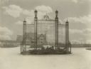
| Date: | 11 21 1931 |
|---|---|
| Description: | View of a wrought iron structure in an "island" garden in the middle of an entryway, with the Great Memorial Building in the background. |

| Date: | |
|---|---|
| Description: | View down a long dirt road. In the distance the road passes under a railroad bridge near a church with a cemetery. Caption reads: "Lover's Lane, Mapleton, ... |
If you didn't find the material you searched for, our Library Reference Staff can help.
Call our reference desk at 608-264-6535 or email us at: