 Filter: Categories of Wisconsin Historical Images
Filter: County of Waukesha
Filter: Subject of dams
Filter: Categories of Wisconsin Historical Images
Filter: County of Waukesha
Filter: Subject of dams

| Date: | 02 1956 |
|---|---|
| Description: | This 1956 map of Waukesha County, Wisconsin, shows the township and range grid, towns, sections, cities and villages, roads, railroads, dams, airports, par... |

| Date: | 1840 |
|---|---|
| Description: | This manuscript map by Increase Lapham shows the railroads, roads, wetlands, lakes and streams, dams, prairies, and settlers in the eastern half of Waukesh... |
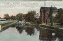
| Date: | 1910 |
|---|---|
| Description: | Colored postcard view of the old mill, stream and a dam. Caption reads: "Old Mill and Race, Near Milwaukee, Wis. At Delafield." |
If you didn't find the material you searched for, our Library Reference Staff can help.
Call our reference desk at 608-264-6535 or email us at: