Filter: Categories of Wisconsin Historical Images
Filter: County of Waupaca
Filter: Subject of lakes
Filter: Categories of Wisconsin Historical Images
Filter: County of Waupaca
Filter: Subject of lakes
| Date: | |
|---|---|
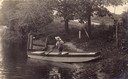
| Description: | Laurie Peterson, son of the photographer, plays in boat. The photograph was originally titled "The Lone Boatsman". |
| Date: | |
|---|---|
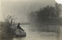
| Description: | View across water towards Laurie Peterson, son of the photographer, fishing from a rock on a misty morning near the family home. |
| Date: | |
|---|---|
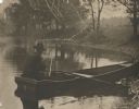
| Description: | View from shoreline of the photographer, Carl A. Peterson, taking a moment to light his pipe while fishing from a boat near the family home. |
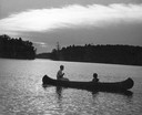
| Date: | 1945 |
|---|---|
| Description: | Couple canoeing under partly cloudy skies with sun dappling the water on Rainbow Lake, Chain O' Lakes. |
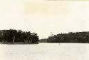
| Date: | 1940 |
|---|---|
| Description: | View of Taylor Lake and the entrance to Chain O' Lakes. |

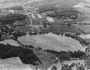
| Date: | 1910 |
|---|---|
| Description: | Aerial view of some of the 26 lakes known collectively as the Chain O' Lakes. Caption reads: "Aeroplane View of Chain O'Lakes, Waupaca, Wis." |
| Date: | 1965 |
|---|---|
| Description: | Aerial view looking west-northwest over Silver Lake. |

| Date: | 1896 |
|---|---|
| Description: | A map of the Chain-O-Lakes in Waupaca, including Indian trails. The path of the Waupaca Electric Railway from the Grand View Hotel to the Wisconsin Central... |
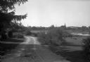
| Date: | |
|---|---|
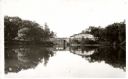
| Description: | View along a dirt road toward a lake, with the town of Weyauwega on the far shoreline. |

| Date: | 1941 |
|---|---|
| Description: | This pictorial map shows sites related to Indian legends, mounds, and trails in the Chain O' Lakes region in southwestern Waupaca County, Wisconsin. |

| Date: | 1898 |
|---|---|
| Description: | This 1896 map of the Chain-O-Lakes region of Waupaca County, Wisconsin, shows the lakes and streams, some topography, archaeological sites, roads, railroad... |

| Date: | 1898 |
|---|---|
| Description: | This 1898 map shows the contour depths of the Chain O' Lakes in Waupaca County, Wisconsin, and includes 15 cross sections of the lakes. Roads, parks, the W... |
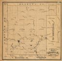
| Date: | 1870 |
|---|---|
| Description: | This 1870 map of Waupaca County, Wisconsin, shows the township and range grid, towns, cities and villages, and lakes and streams. |

| Date: | 1974 |
|---|---|
| Description: | This map includes a diagram on the bottom left margin showing civil towns, a township numbering system, state highways, roads, lakes, and a legend on the r... |
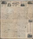
| Date: | 1874 |
|---|---|
| Description: | This map shows townships and sections, land ownership and acreages, churches, schools, cemeteries, roads, railroads, and projected railroads. The map inclu... |

| Date: | 1901 |
|---|---|
| Description: | This map shows landownership and acreages, townships and sections, and selected buildings. |

| Date: | 1914 |
|---|---|
| Description: | View from grassy shoreline looking down at James Peterson, as a young boy, sitting in a rowboat looking over his shoulder back towards the shoreline. He is... |
If you didn't find the material you searched for, our Library Reference Staff can help.
Call our reference desk at 608-264-6535 or email us at: