 Filter: Categories of Wisconsin Historical Images
Filter: County of Waupaca
Filter: Subject of streams
Filter: Categories of Wisconsin Historical Images
Filter: County of Waupaca
Filter: Subject of streams
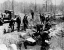
| Date: | 04 26 1936 |
|---|---|
| Description: | Planting trout in Waupaca County. Left to right on bank: S.A. LaVoilette, Joe Samz, Lloyd Pinkawski, Edwin Kargewski, W.M. Geiger, G. Moder, Billy LaVoilet... |

| Date: | 1898 |
|---|---|
| Description: | This 1896 map of the Chain-O-Lakes region of Waupaca County, Wisconsin, shows the lakes and streams, some topography, archaeological sites, roads, railroad... |
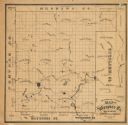
| Date: | 1870 |
|---|---|
| Description: | This 1870 map of Waupaca County, Wisconsin, shows the township and range grid, towns, cities and villages, and lakes and streams. |

| Date: | |
|---|---|
| Description: | Photographic postcard view across a stream toward a dam and adjoining building. There appears to be a silo behind the tree on the left. Caption reads: "Vie... |

| Date: | 1940 |
|---|---|
| Description: | A picturesque view of three people in a rowboat on Otter Creek, with Government Island in the background. A seal at lower right identifies Estberg Photo Se... |
If you didn't find the material you searched for, our Library Reference Staff can help.
Call our reference desk at 608-264-6535 or email us at: