Filter: Categories of Wisconsin Historical Images
Filter: County of Waupaca
Filter: Subject of streets
Filter: Categories of Wisconsin Historical Images
Filter: County of Waupaca
Filter: Subject of streets

| Date: | 1965 |
|---|---|
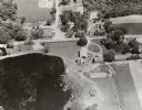
| Description: | Aerial view of downtown Big Falls and the Little Wolf River. The Little Wolf River is at lower right. |
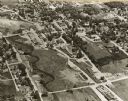
| Date: | 1965 |
|---|---|
| Description: | Aerial view of Iola, Wisconsin looking west. Located in the lower left corner is an elementary school. |
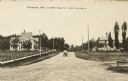
| Date: | 1905 |
|---|---|
| Description: | View down unpaved street. Caption reads: "Residence part of North Main St." |
| Date: | 1905 |
|---|---|
| Description: | Elevated view from Our Savior's Lutheran Church looking west into a residential area. The Methodist Church is in the background. |
| Date: | 1905 |
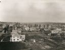
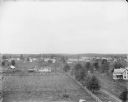
|---|---|
| Description: | A north-facing elevated view of Iola, with Main Street to the right. |
| Date: | 1905 |
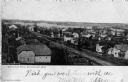
|---|---|
| Description: | Elevated view of the Weyauwega commercial district. Caption reads: "Bird's-Eye View, Weyauwega, Wis." |
| Date: | 1905 |
|---|---|
| Description: | View from street towards the bank. Caption reads: "First National Banks, Weyauwega, Wis." |
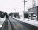
| Date: | 02 12 1970 |
|---|---|
| Description: | State Highway 51 in Iola, Wisconsin, primarily showing the Fire Department and its siren. |
| Date: | |
|---|---|
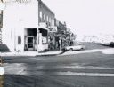
| Description: | Nineteenth century storefronts and angle parking in downtown Iola. |

| Date: | 1930 |
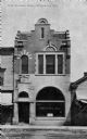
|---|---|
| Description: | Exterior view across street towards the library and museum. Caption reads: "Library and Museum, New London, Wis." |

| Date: | 1905 |
|---|---|
| Description: | View includes a bank and other buildings. People are on the sidewalks. |
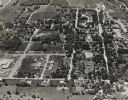
| Date: | 1965 |
|---|---|
| Description: | Aerial view, looking east. Highway 49 is at center. |
| Date: | 1899 |
|---|---|
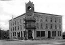
| Description: | View of Hotel Hutchinson, situated at the corner of two streets. The entrance stands beneath a bell tower and a group of boys, some with bicycles, stands n... |
| Date: | |
|---|---|
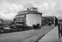
| Description: | A horse-drawn carriage crosses the Mill Street Bridge. Another carriage is parked near the grain elevator. |
| Date: | 1910 |
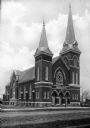
|---|---|
| Description: | View across road toward the front facade and left side of St. Peter's Evangelical Lutheran Church. The Gothic Revival-style structure has two steeples, the... |
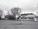
| Date: | 1958 |
|---|---|
| Description: | Exterior of Jung's General Store/Gas Station/Barber Shop. |
If you didn't find the material you searched for, our Library Reference Staff can help.
Call our reference desk at 608-264-6535 or email us at: