 Filter: Categories of Wisconsin Historical Images
Filter: County of Winnebago
Filter: Year of 1900-1999
Filter: Subject of cities and towns
Filter: Categories of Wisconsin Historical Images
Filter: County of Winnebago
Filter: Year of 1900-1999
Filter: Subject of cities and towns

| Date: | 09 1950 |
|---|---|
| Description: | This map show streets, points of interest, Lake Winnebago and bays, Lake Butte Des Morts, and the Fox River. The back of the map includes a directory of t... |

| Date: | 1962 |
|---|---|
| Description: | This map shows streets, points of interest, Lake Winnebago, Millers Bay, South Asylum Bay, Lake Butte des Morts, and the Fox River. The map also includes a... |

| Date: | 1962 |
|---|---|
| Description: | This map shows streets, points of interest, Lake Winnebago, Millers Bay, South Asylum Bay, Lake Butte des Morts, and the Fox River. The map also includes a... |

| Date: | 1930 |
|---|---|
| Description: | This map shows city wards, streets, railroads, parks, Lake Butte Des Morts, Lake Winnebago, advertisements for Dixie Oils Gasoline, a list of Cook & Brown ... |

| Date: | 1974 |
|---|---|
| Description: | This map shows streets, Lake Winnebago, Little Lake Butte Des Morts, and the Fox River. Also included is text on the Fox River Waterways and the history of... |
| Date: | 1963 |
|---|---|
| Description: | A diagonal view down the canal of the Menasha Woodenware Company. Along the opposite side of the canal are boxcars on an elevated railroad track over the w... |

| Date: | 1945 |
|---|---|
| Description: | This map shows block and lot numbers, subdivisions, streets, railroads, and abandoned right of ways. Some areas are shown in yellow and pink. The city seal... |

| Date: | 1908 |
|---|---|
| Description: | This blueprint map is showing subdivisions and additions. Streets, rivers, and land plots are labeled. |

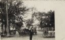
| Date: | 1910 |
|---|---|
| Description: | Exterior view of the Riverside Hotel, North 1st Street opposite the railroad depot. Two women, one holding a dog in her lap, and a man are sitting in chair... |

| Date: | 1931 |
|---|---|
| Description: | This map shows heavy industrial districts (yellow), commercial and light manufacturing districts (red), and residential districts (white) as well as a plat... |

| Date: | 1900 |
|---|---|
| Description: | Map showing a paper city located on the shore of Green Bay and south shore of the Fox River. The site is now part of Oshkosh. |

| Date: | 1900 |
|---|---|
| Description: | Map showing city wards, streets, block and lot numbers, additions, selected buildings, Lake Winnebago, the Fox River, and railroads as of 1895. The lower m... |

| Date: | 1926 |
|---|---|
| Description: | This blueprint map is oriented with north to the upper left. The map shows buildings with note of those "to be torn down," sidewalks, proposed power plant,... |
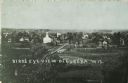
| Date: | 1912 |
|---|---|
| Description: | Elevated view of the town, with a church and dwellings, surrounded by fields. Caption reads: "Birds [sic] Eye View of Eureka, Wis." |

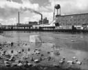
| Date: | 1947 |
|---|---|
| Description: | View across water towards the Kimberly Clark paper mill, with the Neenah Channel in the foreground. |
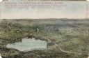
| Date: | 1908 |
|---|---|
| Description: | Illustrated postcard of Lake Winnebago and the surrounding communities. Text on front reads: "Looking northwest from the east shore of Lake Winnebago showi... |
| Date: | 1908 |
|---|---|
| Description: | A man is standing in the street drinking from a jug, and a woman sitting in a wagon is watching him. Horses and wagons are behind him. Caption reads: "A Bu... |
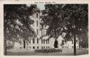
| Date: | 1925 |
|---|---|
| Description: | Exterior view of a high school, with flower beds in the front lawn. Caption reads: "High School, Menasha, Wis." |
If you didn't find the material you searched for, our Library Reference Staff can help.
Call our reference desk at 608-264-6535 or email us at:

