 Filter: Categories of Wisconsin Historical Images
Filter: County of Winnebago
Filter: Year of 1900-1999
Filter: Subject of land
Filter: Categories of Wisconsin Historical Images
Filter: County of Winnebago
Filter: Year of 1900-1999
Filter: Subject of land
| Date: | 1932 |
|---|---|
| Description: | In order to undertake a trans-Atlantic flight to Norway, Clyde Allen Lee sought financial support from the local Oshkosh clothing company. The sign painted... |
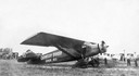
| Date: | 1923 |
|---|---|
| Description: | The hangar and three airplanes (a Canuck and a J-1 Standard) at the airport operated by the Larson Brothers of Larsen, Wisconsin. The field was both the mo... |
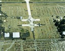
| Date: | 1988 |
|---|---|
| Description: | Aerial view of the 1988 EAA (Experimental Aviation Association) Convention and Fly-in at Wittman Field. On the ground is the Concorde and a B-1 Bomber. |
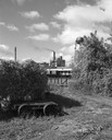
| Date: | 09 29 1963 |
|---|---|
| Description: | The Menasha Woodenware plant and water tower on Doty Island from across the Fox River canal, with a small railroad dolly in the foreground. |
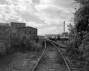
| Date: | 09 29 1963 |
|---|---|
| Description: | View down railroad tracks towards the railroad bridge, with industrial plants on Doty Island. |
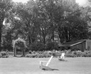
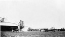
| Date: | 06 16 1963 |
|---|---|
| Description: | Garden, entrance to swimming pool, and pavilion at the Donald Shepard residence, originally the Smith house, built by the son of the founder of the Menasha... |
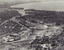
| Date: | 1955 |
|---|---|
| Description: | Aerial view of "the island" with the Marathon Corporation paper mills. The Fox River flowing out of Lake Winnebago separates the two cities, Neenah and Men... |

| Date: | 1910 |
|---|---|
| Description: | Doty's Loggery. Caption printed under image reads: "Governor James Duane Doty, in 1845, built this log house on Doty's Island (Menasha), and resided there ... |

| Date: | 03 1911 |
|---|---|
| Description: | This 1911 topographic map shows Lake Winnebago and the surrounding area. The township and range grid, counties, towns, sections, cities, villages and post ... |

| Date: | 1911 |
|---|---|
| Description: | This 1911 map from the U.S. Post Office Dept. shows rural delivery routes, active and discontinued post offices, collection boxes, selected rural landowner... |

| Date: | 1936 |
|---|---|
| Description: | This map of Neenah and Menasha shows some parks, churches, convention halls, and other buildings. These points of interest are in red ink. Streets, Little ... |

| Date: | 1950 |
|---|---|
| Description: | This map of the business section of Oshkosh shows businesses and lot owners. The map is oriented with north to the left and includes 2 "continued inset" ma... |
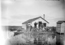
| Date: | 1910 |
|---|---|
| Description: | View across water towards a group of seven men posing on a dock in front of a small hunting shack in the middle of a marsh. Ducks hang on stringers attache... |

| Date: | 1903 |
|---|---|
| Description: | This maps shows what may be Ho Chunk Native American burial mounds. Also noted on the map is the Fox River, the Doty homestead, stockade embankment, the We... |

| Date: | 09 1950 |
|---|---|
| Description: | This map show streets, points of interest, Lake Winnebago and bays, Lake Butte Des Morts, and the Fox River. The back of the map includes a directory of t... |

| Date: | 1962 |
|---|---|
| Description: | This map shows streets, points of interest, Lake Winnebago, Millers Bay, South Asylum Bay, Lake Butte des Morts, and the Fox River. The map also includes a... |

| Date: | 1930 |
|---|---|
| Description: | This map shows city wards, streets, railroads, parks, Lake Butte Des Morts, Lake Winnebago, advertisements for Dixie Oils Gasoline, a list of Cook & Brown ... |

| Date: | 1908 |
|---|---|
| Description: | This blueprint map is showing subdivisions and additions. Streets, rivers, and land plots are labeled. |

| Date: | 1931 |
|---|---|
| Description: | This map shows heavy industrial districts (yellow), commercial and light manufacturing districts (red), and residential districts (white) as well as a plat... |
If you didn't find the material you searched for, our Library Reference Staff can help.
Call our reference desk at 608-264-6535 or email us at:
