Filter: Categories of Wisconsin Historical Images
Filter: FORMAT_DIMENSIONS of ? x ?
Filter: County of Dodge
Filter: Year of 1800-1899
Filter: Categories of Wisconsin Historical Images
Filter: FORMAT_DIMENSIONS of ? x ?
Filter: County of Dodge
Filter: Year of 1800-1899
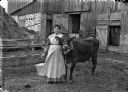
| Date: | 1899 |
|---|---|
| Description: | Grandma Martha (Goetsch) Buelke posed in front of a barn with her favorite cow. She is holding a milking pail. |
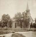
| Date: | 1877 |
|---|---|
| Description: | Stereograph view of the exterior of Assembly Presbyterian Church, surrounded by trees. |

| Date: | 1871 |
|---|---|
| Description: | A family, possibly that of William Bonner, is posing around a table in a yard. A man is sitting on the left holding a paper in one hand and a glass in the ... |
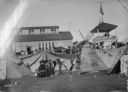
| Date: | 1898 |
|---|---|
| Description: | Native American Indians in traditional dress outside their teepees (tipis) at the Dodge County Fair. There is a large building in the background along with... |
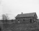
| Date: | 12 03 1899 |
|---|---|
| Description: | View of an old log house on William Wills Farm, residence of Leudwig Goetsch and bought by William Goetsch in 1846. |
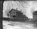
| Date: | 1899 |
|---|---|
| Description: | Exterior view of the Dodge County Workhouse for Transients. |
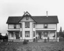
| Date: | 11 30 1899 |
|---|---|
| Description: | Exterior view of the William Wills homestead. The family, including a dog, is standing around the front porch. One young girl is standing inside the house ... |
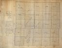
| Date: | 1867 |
|---|---|
| Description: | This manuscript map shows the township and range grid, towns, and sections in Dodge County, Wisconsin. |

| Date: | 1896 |
|---|---|
| Description: | This late 19th-century map of Dodge County, Wisconsin, shows the township and range grid, towns, sections, cities, villages and post offices, some property... |

| Date: | 1852 |
|---|---|
| Description: | Map created between 1852 and 1867 shows numbered lots, labelled roads, the "Centre Line of LaCrosse & Milwaukee R.R." railroad, and a station house. Roads ... |
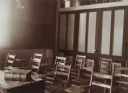
| Date: | 1891 |
|---|---|
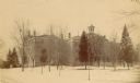
| Description: | "Recitation Room" at Downer College. |

| Date: | 1856 |
|---|---|
| Description: | This map shows a plat of the town, local streets, lots, and part of the Rock River. The margins of the map have manuscript annotations in ink. |

| Date: | 1868 |
|---|---|
| Description: | This map is ink on tracing cloth and shows lot and block numbers, depot, railroads and side tracks, and streets in sections 24 and 25, T.11, R.16E. The map... |

| Date: | 1870 |
|---|---|
| Description: | This map is ink and color on tracing cloth and shows Iron Ridge, the hotel and saw mill at Iron Ridge Village, Milwaukee & St. Paul Railway, plank road, an... |

| Date: | 1846 |
|---|---|
| Description: | This map is paint and ink on board with relief shown pictorially. The map was planned by Alfred Ames, drawn by one daughter and painted by another daughter... |

| Date: | 1895 |
|---|---|
| Description: | Interior of a student's room at Downer (women's) College. Two banjos rest on the chaise in front of the window. |
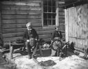
| Date: | 05 1899 |
|---|---|
| Description: | William and Johanna Krueger are sitting alongside a house near a shed. William is sitting on a bench weaving a willow basket, and has a pipe in his mouth. ... |
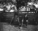
| Date: | 05 1899 |
|---|---|
| Description: | William and Johanna Krueger working in the garden. Johanna is standing next to the garden fence holding a hoe. William is sitting next to her on a small be... |
If you didn't find the material you searched for, our Library Reference Staff can help.
Call our reference desk at 608-264-6535 or email us at: