 Filter: Categories of Wisconsin Historical Images
Filter: FORMAT_DIMENSIONS of ? x ?
Filter: Year of 1700-1799
Filter: Categories of Wisconsin Historical Images
Filter: FORMAT_DIMENSIONS of ? x ?
Filter: Year of 1700-1799
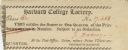
| Date: | 1774 |
|---|---|
| Description: | Ticket for the Harvard College Lottery. |
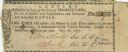
| Date: | 1795 |
|---|---|
| Description: | State of Pennsylvania Lottery ticket authorised by law to benefit the Schuylkill and Susquehanna, and Delaware and Schuylkill Canals. |

| Date: | 1780 |
|---|---|
| Description: | Contenant: New Hampshire, Massachusetsbaye, Rhode Island, Connecticut, La Nouvelle York, Nouvelle Jersey, La Pensilvanie, Les Comtes de Newcastle, Kent et ... |

| Date: | 1798 |
|---|---|
| Description: | Uncolored. No scale. One of the earliest maps to show the proposed division of the northwest territory into states. |

| Date: | 1755 |
|---|---|
| Description: | From "A map of the British and French dominions in North American with the roads, distances, limits, and extent of the settlements". |

| Date: | 1733 |
|---|---|
| Description: | From "A map of the British Empire in America with the French and Spanish settlements adjacent thereto". This is the Wisconsin and Minnesota section. |

| Date: | 1772 |
|---|---|
| Description: | Scale: about 180 miles to 1 in. |

| Date: | 1755 |
|---|---|
| Description: | Color map of North American territories owned by the English and by the French. Scale: about 115 milles d'Angleterre to 1 inch. French title is "Carte des ... |

| Date: | 1761 |
|---|---|
| Description: | A plan of the Straits of St. Mary and Michilimakinac, to shew the situation and importance of the two westernmost settlements of Canada for the fur trade. ... |

| Date: | 07 04 1776 |
|---|---|
| Description: | Hand-drawn map of the area where the Battle of Black's Fort took place. |
| Date: | 07 04 1776 |
|---|---|
| Description: | Notes written in red ink on the back of the map of the Battle of Black's Fort. |

| Date: | 1784 |
|---|---|
| Description: | Map of The United States of America according to the Treaty of Peace of 1784. |
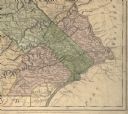
| Date: | 1775 |
|---|---|
| Description: | Detail of Pennsylvania map showing Chester, Philadelphia, and Bucks counties. |

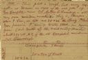
| Date: | 07 1774 |
|---|---|
| Description: | Front page of a letter written and signed by Dan Smith. |

| Date: | 07 1774 |
|---|---|
| Description: | Back page of a letter written and signed by Dan Smith. |
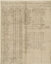
| Date: | 1777 |
|---|---|
| Description: | A pay roll, handwritten by Captain Joseph Martin, listing men under the command of Major Bledsoe at Rye Cove on Clinck. |
| Date: | 1777 |
|---|---|
| Description: | A pay roll handwritten by Captain Joseph Martin listing men stationed on the Frontiers of Washington County under the command of Colonel Evan Shelby. |
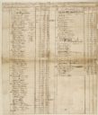
| Date: | 1777 |
|---|---|
| Description: | The back side of Captin Joseph Martin's pay roll from 1 May through 30 June, 1777. There are columns of numbers beneath the writing. |

| Date: | 1744 |
|---|---|
| Description: | Paris: 1744. W 92⁰--W 76⁰/N 49⁰--N 41⁰. Scale [ca. 1:4,000,000] |

| Date: | 1778 |
|---|---|
| Description: | Hand-colored. London, 1778. Coordinates: W 99⁰--W 83⁰/N 49⁰--N 41⁰. Scale [ca. 1:3,500,000] |
If you didn't find the material you searched for, our Library Reference Staff can help.
Call our reference desk at 608-264-6535 or email us at: