 Filter: Categories of Wisconsin Historical Images
Filter: FORMAT_DIMENSIONS of 11 x 17 inches
Filter: Type of Map or Atlas
Filter: Categories of Wisconsin Historical Images
Filter: FORMAT_DIMENSIONS of 11 x 17 inches
Filter: Type of Map or Atlas

| Date: | 1853 |
|---|---|
| Description: | Plan no. 3. Scale 2000 feet to one inch. |

| Date: | 1839 |
|---|---|
| Description: | Map of a canal route to avoid the principal rapids of the Neenah or Fox River between Lake Winnebago and Green Bay. |
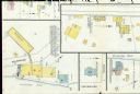
| Date: | 03 1904 |
|---|---|
| Description: | Detail of a Sanborn map of Grafton including the Sheboygan Knitting Company. |
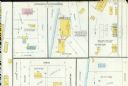
| Date: | 10 1910 |
|---|---|
| Description: | Detail of a Sanborn Map of Grafton including the Northern Chair Company. |
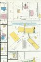
| Date: | 07 1929 |
|---|---|
| Description: | A detail of a Sanborn map of Grafton including the New York Recording Laboratory. |

| Date: | 1910 |
|---|---|
| Description: | Left half of a plat map of Hustisford in Dodge County. |

| Date: | 1910 |
|---|---|
| Description: | The right half of a plat map of Hustisford in Dodge County. |
If you didn't find the material you searched for, our Library Reference Staff can help.
Call our reference desk at 608-264-6535 or email us at: