 Filter: Categories of Wisconsin Historical Images
Filter: FORMAT_DIMENSIONS of 14 x 18 inches
Filter: Subject of cities and towns
Filter: Categories of Wisconsin Historical Images
Filter: FORMAT_DIMENSIONS of 14 x 18 inches
Filter: Subject of cities and towns

| Date: | 1890 |
|---|---|
| Description: | Portion of a plat map of Madison featuring Lake Mendota. |

| Date: | 1890 |
|---|---|
| Description: | Left half of a plat map of the "East Part of the city of Madison". |

| Date: | 1890 |
|---|---|
| Description: | Right side of a plat map of the "East Part of the City of Madison". |

| Date: | 1890 |
|---|---|
| Description: | Portion of a plat map of the "West Part of the City of Madison". |

| Date: | 1951 |
|---|---|
| Description: | Nighttime elevated view of the S.C. Johnson Wax Company research tower, designed by Frank Lloyd Wright. |
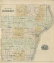
| Date: | 1878 |
|---|---|
| Description: | Outline map of Manitowoc County. Includes engraving of Wisconsin State Seal at bottom right. |

| Date: | 1911 |
|---|---|
| Description: | A decorative page featuring Dane County public buildings, including a court house, a jail, the poor farm building, and two views of an asylum. |

| Date: | 1887 |
|---|---|
| Description: | A plat map of Waterford. Township 4, North Range 19, East of 4th Principal Meridian. References at bottom include school houses, houses, churches and cemet... |
If you didn't find the material you searched for, our Library Reference Staff can help.
Call our reference desk at 608-264-6535 or email us at:
