 Filter: Categories of Wisconsin Historical Images
Filter: FORMAT_DIMENSIONS of 28 x 22 inches
Filter: Type of Map or Atlas
Filter: Categories of Wisconsin Historical Images
Filter: FORMAT_DIMENSIONS of 28 x 22 inches
Filter: Type of Map or Atlas

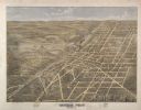
| Date: | 1870 |
|---|---|
| Description: | During the War of 1812, the only battle fought in Wisconsin was in Prairie du Chien, in 1814. Made fifty-six years later, this birds eye drawing depicts th... |

| Date: | 1896 |
|---|---|
| Description: | Bird's-eye map of Darlington. Area bordered by Washington and North Streets, upper left hand corner, the fairgrounds, upper right corner, River Street, bot... |
| Date: | 1872 |
|---|---|
| Description: | Bird's-eye map of Mineral Point, looking southeast. |

| Date: | 1879 |
|---|---|
| Description: | Bird's-eye view drawing of various buildings on the University of Wisconsin-Madison. Buildings include: Ladies Hall, South Dormitory, University Hall, Asse... |
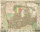
| Date: | 1849 |
|---|---|
| Description: | Map reads, "Map of the Western States". Published by Ensign & Thayer. There is a decorative vine border, and in each corner there is an engraving of four c... |
| Date: | 1967 |
|---|---|
| Description: | Schematic Master Plan for the City of Madison, Wisconsin. William Wesley Peters, Architect • The Frank Lloyd Wright Foundation. |
If you didn't find the material you searched for, our Library Reference Staff can help.
Call our reference desk at 608-264-6535 or email us at: