 Filter: Categories of Wisconsin Historical Images
Filter: FORMAT_DIMENSIONS of 3.75x2.75
Filter: Year of 1900-1999
Filter: Categories of Wisconsin Historical Images
Filter: FORMAT_DIMENSIONS of 3.75x2.75
Filter: Year of 1900-1999
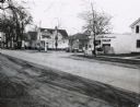
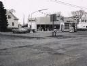
| Date: | 1967 |
|---|---|
| Description: | A Standard Oil service station located on Oxford Street (State Highway 21&73) in Wautoma, Wisconsin. This photograph relates to the neighborhood view in 3... |
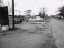
| Date: | 1967 |
|---|---|
| Description: | Deep Rock gasoline service station located at the intersection of Scott Street and Oxford Street (STH 21&73) in Wautoma, Wisconsin. |
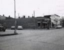
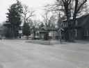
| Date: | 1967 |
|---|---|
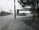
| Description: | Storefronts at the intersection of St. Marie Street and Oxford Street (STH 21&73) in Wautoma, Wisconsin. |
| Date: | 1967 |
|---|---|
| Description: | Zephyr gasoline station on STH 21&73 in Wautoma, Wisconsin. |
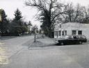
| Date: | 1967 |
|---|---|
| Description: | Mobil Oil service station on the corner of STH 22 and STH 21&73. |
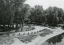
| Date: | 09 20 1972 |
|---|---|
| Description: | Wayside #8 near Necedah in rural Adams County. |
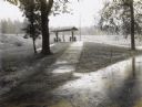
| Date: | 09 30 1970 |
|---|---|
| Description: | Point Bluff Wayside as viewed from the highway bridge above. |
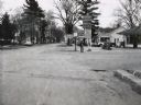
| Date: | 07 26 1967 |
|---|---|
| Description: | Buildings of the Gumz muck farm, near Packwaukee, Wisconsin. |

| Date: | 05 21 1968 |
|---|---|
| Description: | Rural tavern and gasoline station on STH 54. |
| Date: | 1967 |
|---|---|
| Description: | Waupaca Tree Service at the intersection of STH 24 and King Road with station wagon parked in front. |
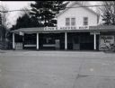
| Date: | 1967 |
|---|---|
| Description: | King's Koffee Kup, a restaurant located on STH 22. |
| Date: | 1967 |
|---|---|
| Description: | Bungalow-style house located on STH 22, that had been converted into a beer garden and bait shop. |
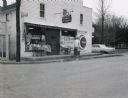
| Date: | 1967 |
|---|---|
| Description: | Carlson's One Stop Market located on STH 22. |
| Date: | 1967 |
|---|---|
| Description: | Handle's Bar and Motel, located along STH 22 in King, Wisconsin, at the intersection with Grand View Road. Another motel can be seen in the distance acros... |

| Date: | 03 28 1969 |
|---|---|
| Description: | Stone bridge over Two Mile Creek in Wood County. The creek is not frozen although the ground is snow-covered. |

| Date: | 09 1982 |
|---|---|
| Description: | Nollenberg Road Bridge in the Town of Union. |

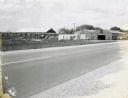
| Date: | 1967 |
|---|---|
| Description: | The Clark Oil Company station at the corner of State Highway 73 & 21 and Baxter Avenue. |
| Date: | 08 1936 |
|---|---|
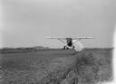
| Description: | Airplane owned by the Agricultural Dusting Service of Ft. Lauderdale, Florida, dusting a cranberry marsh in Wood County for leaf hoppers. The photographer ... |
If you didn't find the material you searched for, our Library Reference Staff can help.
Call our reference desk at 608-264-6535 or email us at: