Filter: Categories of Wisconsin Historical Images
Filter: FORMAT_DIMENSIONS of 4.5 x 6.5 inches
Filter: Creator Name of Unknown
Filter: Subject of cities and towns
Filter: Categories of Wisconsin Historical Images
Filter: FORMAT_DIMENSIONS of 4.5 x 6.5 inches
Filter: Creator Name of Unknown
Filter: Subject of cities and towns
| Date: | 1860 |
|---|---|
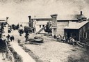
| Description: | Elevated view of Barstow Street looking north. View from the corner of Main Street, where the Eau Claire Book and Stationary Company later stood, looking n... |
| Date: | 1918 |
|---|---|
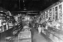
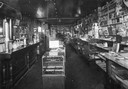
| Description: | Rial Herreman, Sr. and Rial Herreman, Jr. inside the Herreman Drugstore in Boyd, Wisconsin. |
| Date: | 1918 |
|---|---|
| Description: | Detailed interior view of the Herreman Drugstore in Boyd, Wisconsin. |

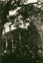
| Date: | 1915 |
|---|---|
| Description: | Exterior view of the Frederick Karberg house located at 25 North Blair Street. The house was later moved to the corner of East Johnson and North Livingston... |
| Date: | 1918 |
|---|---|
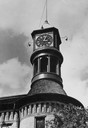
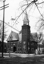
| Description: | View across and down a street towards the Baraboo City Hall. |
| Date: | 1920 |
|---|---|
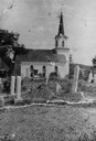
| Description: | German Evangelical Association Church and adjacent cemetery, also known as Zion Evangelical Church. When services were discontinued in the early 1920s the... |
| Date: | 1870 |
|---|---|
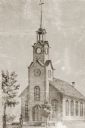
| Description: | View of a Baptist church, two small trees, and a man standing in front of the church, wearing a top hat. Baptist Church, 4th Avenue and Niagara Street, bui... |

| Date: | 1870 |
|---|---|
| Description: | Third Ward, East Side, or "Bartlett School." This is probably the earliest picture in existence and is copied form the margin of "an old map." This first... |

| Date: | 1932 |
|---|---|
| Description: | View of a log cabin in Colonel Heg Memorial Park. Built in 1837, the cabin was the homestead of the Even Hansen Heg family after they emigrated from Lier, ... |
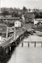
| Date: | 1865 |
|---|---|
| Description: | Elevated view of a bridge and logging debris around residential homes. |
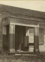
| Date: | 1922 |
|---|---|
| Description: | Detail of the entrance of the American Fur Company warehouse, also called Old Treaty Hall. In 1832 the fur company moved its Bayfield post to the Island (M... |
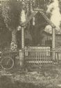
| Date: | 1890 |
|---|---|
| Description: | A shrine put up by J.H. Van Niel, who came over with Fr. Van den Broek. Destroyed about 1895. |
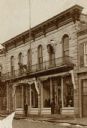
| Date: | 1875 |
|---|---|
| Description: | The Gundry, Gray and Company store. The building was erected in 1841 and the dog on the sign was added in 1871. |
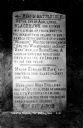
| Date: | 04 1930 |
|---|---|
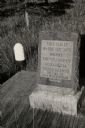
| Description: | View of a historical marker commorating Black Hawk's surrender in 1832, located on Highway 35. Caption reads: "Tablet on Highway #35 * Victory, Wis." |
| Date: | 1930 |
|---|---|
| Description: | View looking up towards the front of a Milton College building. |
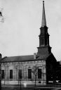
| Date: | 1935 |
|---|---|
| Description: | View of the First Presbyterian Church from the northeast. |
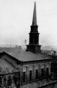
| Date: | 1935 |
|---|---|
| Description: | Elevated view of the First Presbyterian Church from the southeast. A water tower is in the background. |
| Date: | 1940 |
|---|---|
| Description: | A marker at the site of the former village of Oshaukuta on Highway 51, north of Portage. The marker states: "This tablet marks the site where the village o... |
If you didn't find the material you searched for, our Library Reference Staff can help.
Call our reference desk at 608-264-6535 or email us at: