 Filter: Categories of Wisconsin Historical Images
Filter: FORMAT_DIMENSIONS of 7.5 x 7.5 inches
Filter: Subject of transportation
Filter: Subject of cities and towns
Filter: Categories of Wisconsin Historical Images
Filter: FORMAT_DIMENSIONS of 7.5 x 7.5 inches
Filter: Subject of transportation
Filter: Subject of cities and towns
| Date: | |
|---|---|
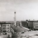
| Description: | Elevated view from the Wisconsin State Capitol looking east, towards the old Water Works tower on East Washington Avenue. |
| Date: | 1914 |
|---|---|
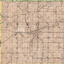
| Description: | The Verona township, a detail of the Dane County, Wisconsin map of land ownership. |

| Date: | 1861 |
|---|---|
| Description: | The township of Primrose, which is a detail from the plat map of Dane County. |

| Date: | 1861 |
|---|---|
| Description: | The township of Montrose, which is a detail from a Dane County plat map. |
If you didn't find the material you searched for, our Library Reference Staff can help.
Call our reference desk at 608-264-6535 or email us at:

