 Filter: Categories of Wisconsin Historical Images
Filter: FORMAT_DIMENSIONS of 8 X 10 inches
Filter: Subject of fields (agriculture)
Filter: Subject of roads
Filter: Categories of Wisconsin Historical Images
Filter: FORMAT_DIMENSIONS of 8 X 10 inches
Filter: Subject of fields (agriculture)
Filter: Subject of roads

| Date: | 11 1951 |
|---|---|
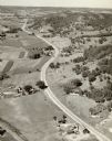
| Description: | Aerial view of US Highway 14 southeast of La Crosse descending into Mormon Coulee. The original caption of the print, which is undated, describes the road ... |

| Date: | 1950 |
|---|---|
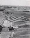
| Description: | Aerial view of a farm and surrounding fields farmed with the contour method. Shocks of grain dot several of the fields. |

| Date: | 1921 |
|---|---|
| Description: | Front cover of an advertisement for the Rumely 1 1/2 ton farm truck. An illustration depicts a man driving the truck past a cornfield and farm buildings. |
| Date: | |
|---|---|
| Description: | Aerial view of a road, with several farms, fields and hills along it. Caption reads: "U.S. 16 near La Crosse, Wis." |
| Date: | 1956 |
|---|---|
| Description: | Aerial view of contour farming. Farms and patches of woods are spread out in the landscape. |
| Date: | 1979 |
|---|---|
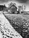
| Description: | A barn and silo, on a snow covered farm along Highway 78, between Mt. Horeb and Black Earth. The farmhouse is behind the barn. A barbed wire fence lines th... |
If you didn't find the material you searched for, our Library Reference Staff can help.
Call our reference desk at 608-264-6535 or email us at: