Filter: Categories of Wisconsin Historical Images
Filter: FORMAT_DIMENSIONS of unknown
Filter: Subject of transportation
Filter: County of Dane
Filter: Categories of Wisconsin Historical Images
Filter: FORMAT_DIMENSIONS of unknown
Filter: Subject of transportation
Filter: County of Dane
| Date: | 1974 |
|---|---|
| Description: | A view looking down from the Wisconsin State Historical Society building to artwork on the cement of State Street Mall. These paintings on the 800 and 900 ... |
| Date: | |
|---|---|
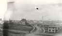
| Description: | Elevated view of University Heights, looking north from Ely Place towards Bascom Hall. The following houses are visible: Professor Richard T. Ely house, 20... |
| Date: | 1863 |
|---|---|
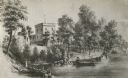
| Description: | View of the shoreline on the Walker Castle grounds. Two men are boating while a young boy fishes from the shore. |

| Date: | 2009 |
|---|---|
| Description: | View of Stoughton city hall building, clock tower and second-story opera house from across street. |
| Date: | |
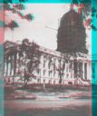
|---|---|
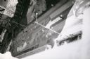
| Description: | Stereograph view of construction of the Wisconsin State Capitol dome during the construction of the fourth capitol building. The image features the Capitol... |
| Date: | 1930 |
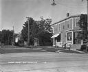
|---|---|
| Description: | A man and his two children pose at the corner near the post office. |
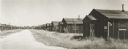
| Date: | 1947 |
|---|---|
| Description: | Abandoned enlisted men's barracks at Truax Field. |

| Date: | |
|---|---|
| Description: | Detail from a drawing of a plan for the isthmus. |

| Date: | 1959 |
|---|---|
| Description: | This map shows wards and precincts by number, local streets, roads, parks, Shorewood Hills, Maple Bluff, Middleton, Verona, McFarland, Monona, Truax Field,... |
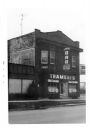
| Date: | 1974 |
|---|---|
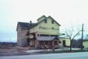
| Description: | An exterior view of Trameri's Bar at 625 West Main Street. |

| Date: | 1908 |
|---|---|
| Description: | Sanborn map of Madison, including West Gilman and Langdon Streets. |

| Date: | 12 1912 |
|---|---|
| Description: | Sanborn map of Sun Prairie, which includes an index and information about water facilities and the fire department. Includes a small inset map of the State... |

| Date: | 12 1912 |
|---|---|
| Description: | Sanborn map of Sun Prairie, showing Main, Center and Church Streets. |

| Date: | 12 1912 |
|---|---|
| Description: | Sanborn Map of Sun Prairie. The map highlights the public and parochial schools, the exhange, and church buildings, etc. |

| Date: | |
|---|---|
| Description: | Exterior view of the Mt. Horeb Co-op Creamery at 102 South Second Street, which was operated by the Ryser Brothers. This view shows a Bavarian-style front,... |

| Date: | 1908 |
|---|---|
| Description: | A Sanborn map featuring the Capitol Square and surrounding business district. |

| Date: | |
|---|---|
| Description: | Exterior view of the house at 1240 Sherman Avenue. |

| Date: | 1890 |
|---|---|
| Description: | Plat map of Madison, T7N R9E, including portions of the towns of Blooming Grove and Burke. Includes inset maps of South Madison, Quarrytown, Marril Park, a... |

| Date: | 1908 |
|---|---|
| Description: | A Sanborn map of the isthmus, which includes the map key. |
If you didn't find the material you searched for, our Library Reference Staff can help.
Call our reference desk at 608-264-6535 or email us at: