Filter: Categories of Wisconsin Historical Images
Filter: FORMAT_DIMENSIONS of unknown
Filter: Subject of transportation
Filter: Subject of church buildings
Filter: Categories of Wisconsin Historical Images
Filter: FORMAT_DIMENSIONS of unknown
Filter: Subject of transportation
Filter: Subject of church buildings
| Date: | |
|---|---|
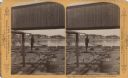
| Description: | Stereograph of a man standing on the back of a raft holding a hand-hewned oar. The raft is passing under a wooden bridge. A town, including a church, are i... |

| Date: | 12 08 1925 |
|---|---|
| Description: | Westminster Presbyterian Church.1806 West Lawn Avenue. Wingra Park. |

| Date: | 1842 |
|---|---|
| Description: | American Fur Company with both Mission churches. Sketch purportedly by a Native American youth. Probably an overpainted photographic copy enlargement. Pape... |

| Date: | 1913 |
|---|---|
| Description: | A wall atlas of Sauk County, Wisconsin, displaying its 22 towns. On the left side are advertisements for local businesses. |

| Date: | |
|---|---|
| Description: | Stereograph of a man standing on the back of a raft holding a hand-hewned oar. The raft is passing under a wooden bridge. A town, including a church, are i... |

| Date: | |
|---|---|
| Description: | Stereograph of southwest facade on Martin Street. Built circa 1872. Architect was E.T. Mix. Dirt road in front, and the tower of the Immanuel Church is in... |

| Date: | 1874 |
|---|---|
| Description: | Stereograph of elevated view looking northwest from Exposition Building. There is a church on a street corner on the left, and the Best Brewing Company in ... |

| Date: | |
|---|---|
| Description: | This detailed map shows fortifications, headquarters, location and dates of battles, street outline of Atlanta, roads, railroads, vegetation, drainage, rel... |

| Date: | 12 1912 |
|---|---|
| Description: | Sanborn map of Sun Prairie, which includes an index and information about water facilities and the fire department. Includes a small inset map of the State... |

| Date: | 12 1912 |
|---|---|
| Description: | Sanborn map of Sun Prairie, showing Main, Center and Church Streets. |

| Date: | 12 1912 |
|---|---|
| Description: | Sanborn Map of Sun Prairie. The map highlights the public and parochial schools, the exhange, and church buildings, etc. |

| Date: | 04 1901 |
|---|---|
| Description: | A Sanborn map of Watertown, including an index and a key. |
If you didn't find the material you searched for, our Library Reference Staff can help.
Call our reference desk at 608-264-6535 or email us at: