 Filter: Categories of Wisconsin Historical Images
Filter: FORMAT_DIMENSIONS of unknown
Filter: Subject of transportation
Filter: Subject of rivers
Filter: Categories of Wisconsin Historical Images
Filter: FORMAT_DIMENSIONS of unknown
Filter: Subject of transportation
Filter: Subject of rivers
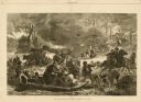
| Date: | 11 25 1871 |
|---|---|
| Description: | Engraved view of Peshtigo Fire showing people trying to escape the flames by boat and on horseback. A team of cattle also seek refuge and several birds tak... |

| Date: | 02 21 1882 |
|---|---|
| Description: | Chromolithograph poster advertising a Milwaukee Mardi Gras celebration, arranged by the Turnverein and Milwaukee Musical Societies, and held at the Exposit... |
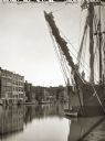
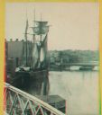
| Date: | |
|---|---|
| Description: | Schooners docked on river. The view is downriver from the Grand Avenue Bridge. |

| Date: | 1866 |
|---|---|
| Description: | Full-length portrait of Morgan L. Martin standing in a landscape, with a dog sitting at his feet. |
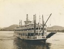
| Date: | 1901 |
|---|---|
| Description: | The sternwheel excursion, J.S., near Trempealeau, taken between 1901 and 1910. |

| Date: | 1862 |
|---|---|
| Description: | Drawn the second year of the Civil War, this 1862 map of Milwaukee shows post offices, light houses, beacon lights, county buildings, elevator warehouses, ... |
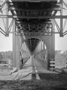
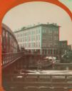
| Date: | |
|---|---|
| Description: | Interior of railroad bridge, with walkway below. There is a man standing on the left at the railing of the walkway. |

| Date: | 1836 |
|---|---|
| Description: | The top map is the "Plat of Madison the Capitol of Wisconsin." The bottom map is the "Map of the Four Lake Country. Taken from the Township Maps in the U.S... |

| Date: | |
|---|---|
| Description: | A Menominee Indian Village on Wolf River. There are dwellings on the shore and many people in canoes are on the river. |

| Date: | 1913 |
|---|---|
| Description: | A wall atlas of Sauk County, Wisconsin, displaying its 22 towns. On the left side are advertisements for local businesses. |
| Date: | 1886 |
|---|---|
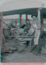
| Description: | Stereograph of men unloading lumber off a raft. A man at the left loads lumber onto a horse-drawn wagon while a man in an apron holds the horses. There is ... |
| Date: | 1886 |
|---|---|
| Description: | Stereograph of Ashley Bennett ("Cookie") who volunteered his services during the float, and the cook Mike Lane, on the Arpin fleet of lumber rafts. |
| Date: | 1886 |
|---|---|
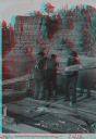
| Description: | Stereograph of four raftsmen shipping an oar in the Dells. |
| Date: | |
|---|---|
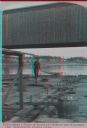
| Description: | Stereograph of a man standing on the back of a raft holding a hand-hewned oar. The raft is passing under a wooden bridge. A town, including a church, are i... |
| Date: | 1880 |
|---|---|
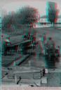
| Description: | Stereograph. Part of a bridge is visible in the lower left corner. Under the bridge is a floating pier with advertisements painted on its sides. Another br... |
| Date: | 1869 |
|---|---|
| Description: | Stereograph of the Axtell House building, with a storefront next to it advertising "Clothing Hats Caps Sailors Outfits". A bridge is on the left and a man... |

| Date: | 1865 |
|---|---|
| Description: | This map of the Bentonville, N.C., battlefield illustrates the positions of the Union and the Confederate troops, roads, rivers, vegetation, and the names ... |
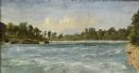
| Date: | 1856 |
|---|---|
| Description: | "....The third view was twelve miles farther up the river [from De Pere], at Rapid Croche, on the border of the present Brown and Outagamie counties. It is... |

| Date: | 1873 |
|---|---|
| Description: | A hand-colored map of Minnesota, Wisconsin, and Michigan shows the counties, cities, villages, rivers, lakes, railroads, and steamboat routes in these stat... |
If you didn't find the material you searched for, our Library Reference Staff can help.
Call our reference desk at 608-264-6535 or email us at:
