 Filter: Categories of Wisconsin Historical Images
Filter: FORMAT_DIMENSIONS of unknown
Filter: Subject of transportation
Filter: Year of 1900-1999
Filter: Year of 1900-1909
Filter: Categories of Wisconsin Historical Images
Filter: FORMAT_DIMENSIONS of unknown
Filter: Subject of transportation
Filter: Year of 1900-1999
Filter: Year of 1900-1909
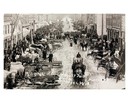
| Date: | 1908 |
|---|---|
| Description: | Elevated view of farmer's wagons, teams, and pedestrian traffic crowd Princeton's main street for the monthly market fair. Some snow is on the ground and a... |
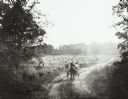
| Date: | 1906 |
|---|---|
| Description: | View down tree-lined country road near Wausau, taken by Dr. Joseph Smith, talented amateur photographer. It depicts women (probably members of his family) ... |
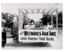
| Date: | 1902 |
|---|---|
| Description: | A traveling medicine wagon with saleswomen and vendor selling Westmore's Hair Tonic. |
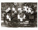
| Date: | 08 31 1909 |
|---|---|
| Description: | A coaching party of festively clad men, women, and children departing for the Annual Scottish Games sponsored by the St. Andrews Society. Some participants... |
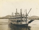
| Date: | 1901 |
|---|---|
| Description: | The sternwheel excursion, J.S., near Trempealeau, taken between 1901 and 1910. |

| Date: | 1909 |
|---|---|
| Description: | Russian advertising poster for International Harvester farm machinery. Includes color illustrations of stationary engines, threshing machines, a horse-draw... |

| Date: | 1900 |
|---|---|
| Description: | View across intersection toward the library on the left, and houses behind a tree-lined sidewalk on the right. |
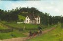
| Date: | 1906 |
|---|---|
| Description: | This oil painting is a fine weave cotton support (perhaps a bed sheet). It is signed and dated (1906) and depicts an early twentieth century rural southwes... |
| Date: | 1900 |
|---|---|
| Description: | A Sanborn map of a portion of Seymour, Wisconsin. |

| Date: | 1908 |
|---|---|
| Description: | Sanborn map of Madison, including West Gilman and Langdon Streets. |

| Date: | 1909 |
|---|---|
| Description: | This the second of a set of two topographical maps showing land use, roads, railroads, bridges, and buildings with ownership in parts of LaFayette, Greenfi... |

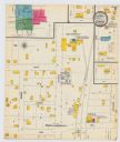
| Date: | 1908 |
|---|---|
| Description: | A Sanborn map featuring the Capitol Square and surrounding business district. |
If you didn't find the material you searched for, our Library Reference Staff can help.
Call our reference desk at 608-264-6535 or email us at:


