 Filter: Categories of Wisconsin Historical Images
Filter: FORMAT_NUMBER_ORG of CF 14
Filter: Subject of roads
Filter: Categories of Wisconsin Historical Images
Filter: FORMAT_NUMBER_ORG of CF 14
Filter: Subject of roads

| Date: | 05 26 1947 |
|---|---|
| Description: | View across road and fields towards three wooded hill peaks. A roadside fence is in the foreground. Caption reads: "D.A. 36-268 — Three peaks on Hy.71 betw... |

| Date: | 07 23 1960 |
|---|---|
| Description: | View from a bluff looking south. A highway is on the right; one farm building is among a stand of trees at the bottom of the hill. |

| Date: | 11 23 1949 |
|---|---|
| Description: | Elevated view of a field, with farmland, roads, houses, and groves of trees. |

| Date: | |
|---|---|
| Description: | Slightly elevated view of a curving road, with telephone poles along it. The road leads down a hillside and is lined with fields and groves of trees. Capti... |
| Date: | 07 1964 |
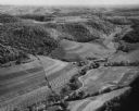
|---|---|
| Description: | Aerial view of fields along hills, surrounded by forests. There are roads and buildings, and hay bales in the field. |

| Date: | 06 1950 |
|---|---|
| Description: | View across a gently sloping prairie field. Trees are in the distance, and power lines and a road are on the left. The Highway Commission descriptive remar... |
If you didn't find the material you searched for, our Library Reference Staff can help.
Call our reference desk at 608-264-6535 or email us at: