 Filter: Categories of Wisconsin Historical Images
Filter: FORMAT_TYPE of architectural drawings
Filter: Categories of Wisconsin Historical Images
Filter: FORMAT_TYPE of architectural drawings

| Date: | 1900 |
|---|---|
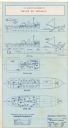
| Description: | Blueprint showing the elevation of Gate "X" for Stanley McCormick's Riven Rock estate at El Montecito, Santa Barbara, California. The blueprint shows a vie... |

| Date: | 1897 |
|---|---|
| Description: | Topographical map of Stanley McCormick's Riven Rock estate in El Montecito, Santa Barbara County, California. The map is identified as a map of a survey co... |
| Date: | |
|---|---|
| Description: | A blueprint showing the second floor balcony outside of the linen room of Stanley McCormick's Riven Rock estate in El Montecito, Santa Barbara County, Cali... |
| Date: | 1900 |
|---|---|
| Description: | Blueprint showing the mantles at Stanley McCormick's Riven Rock estate in El Montecito, Santa Barbara County, California. The architectural firm is identif... |

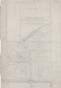
| Date: | 1899 |
|---|---|
| Description: | Topographical map showing ridges, water courses, boundary lines, and trails and roads near the Stanley McCormick's Riven Rock estate in El Montecito, Santa... |

| Date: | 1899 |
|---|---|
| Description: | Map of the Santa Barbara Channel California area showing property boundaries and some geographical features. The Riven Rock Estate has been outlined in yel... |

| Date: | |
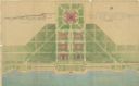
|---|---|
| Description: | Blueprint of the formal garden for Stanley McCormick's Riven Rock estate at El Montecito, Santa Barbara County, California. The blueprint shows different v... |
| Date: | |
|---|---|
| Description: | A drawing of the south elevation of the east portion of a terrace at the Riven Rock McCormick Family Estate in El Montecito, Santa Barbara County, Californ... |
| Date: | 1899 |
|---|---|
| Description: | Architectural drawing of the East Elevation of the terrace at Riven Rock, Stanley McCormick's estate in El Montecito, Santa Barbara County, California. The... |

| Date: | 1899 |
|---|---|
| Description: | Overhead map of the Stanley McCormick's Riven Rock estate in El Montecito, Santa Barbara, California. The map shows the placement of dwellings and fields, ... |

| Date: | 1899 |
|---|---|
| Description: | A map showing the shoreline of a portion of El Montecito, Santa Barbara County, California. The map shows properties along the Pacific Ocean, and may have ... |

| Date: | 1938 |
|---|---|
| Description: | Blueprint for a restored grist mill at Walnut Grove, the McCormick farm in Virginia. The text at bottom right reads, "Grist Mill for Mr. Harold F. McCormic... |
| Date: | 06 09 1986 |
|---|---|
| Description: | A blueprint prepared for Emile de Antonio by the de Pavloff Company in San Francisco. The blueprint is a rendering of "Rainbow Warrior II," a proposed nava... |

| Date: | 06 08 1960 |
|---|---|
| Description: | Blueprint plat of Sunset Hills sub-division. |
| Date: | 1938 |
|---|---|
| Description: | Architectural drawing of the Sunset Village neighborhood on the West side of the city of Madison. The poster description reads: A proposed master plan for ... |
| Date: | 07 1939 |
|---|---|
| Description: | An architectural rendering of a proposed lakefront development plan. |

| Date: | 1930 |
|---|---|
| Description: | This map shows a proposed floor plan for a sheet metal works. |
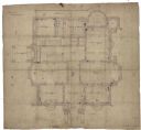
| Date: | |
|---|---|
| Description: | Original drawing of the first floor of the McCormick residence, 675 Rush Street, Chicago, Illinois. Construction started after the Chicago fire in 1874, an... |
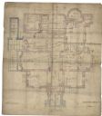
| Date: | 1874 |
|---|---|
| Description: | Original drawing of the basement of the McCormick residence, 675 Rush Street, Chicago, Illinois. Construction started after the Chicago fire in 1874, and w... |
| Date: | 1874 |
|---|---|
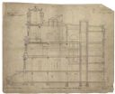
| Description: | Original "Section-through-Centre-of-House-from-West-to-East" drawing of the McCormick residence, 675 Rush Street, Chicago, Illinois. Construction started a... |
If you didn't find the material you searched for, our Library Reference Staff can help.
Call our reference desk at 608-264-6535 or email us at: