Filter: Categories of Wisconsin Historical Images
Filter: FORMAT_TYPE of drawings
Filter: Community of Green Bay
Filter: Categories of Wisconsin Historical Images
Filter: FORMAT_TYPE of drawings
Filter: Community of Green Bay
| Date: | |
|---|---|
| Description: | View of a fort with fortified walls and a flag flying from the fort. A river runs on the right of the image. A boat with sails floats on the river. Sold... |

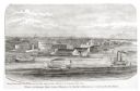
| Date: | 1851 |
|---|---|
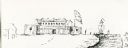
| Description: | Several men rowing in a boat near Fort Howard that has an American Flag, barracks, and various related military buildings enclosed behind a wall. |
| Date: | 1857 |
|---|---|
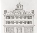
| Description: | Green Bay Intelligencer Newspaper Office. This was the first newspaper published in Wisconsin. The building was on Main Street. This drawing appeared in an... |
| Date: | 1957 |
|---|---|
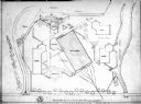
| Description: | Plot plan for a proposed transportation museum. |
| Date: | 1876 |
|---|---|
| Description: | View looking southeast over river from Elmore and Kelly's Elevator. |
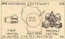
| Date: | |
|---|---|
| Description: | Line drawing in black ink of a design for the Wisconsin Centennial 3 cent postage stamp, featuring Wisconsin State Capitol buildings. The artist used the w... |

| Date: | 1835 |
|---|---|
| Description: | Ink on tracing paper map of Green Bay, Wisconsin and nearby areas, Lake Winnebago, Fox and Wolf Rivers, and the junctions of the Mississippi and Wisconsin ... |

| Date: | |
|---|---|
| Description: | This 19th century manuscript map shows lots and acreages in northern Green Bay, Wisconsin, east of the Fox River. "Preble Township, Brown County, Wis." is ... |

| Date: | 1836 |
|---|---|
| Description: | This manuscript shows the 1835 survey of the road corresponding approximately to a portion of County Trunk A in the Town of Scott, Brown County, Wisconsin.... |

| Date: | 1900 |
|---|---|
| Description: | This photocopied map shows private claim owners, buildings, and land use in 1818. Insets show Fort Howard and the caption reads: "A view of the Fox River ... |

| Date: | 1862 |
|---|---|
| Description: | This map shows landownership on a military reserve, private claims, buildings (including Fort Howard and U.S. sawmill), swamps, public barns and fields, an... |
If you didn't find the material you searched for, our Library Reference Staff can help.
Call our reference desk at 608-264-6535 or email us at: