Filter: Categories of Wisconsin Historical Images
Filter: FORMAT_TYPE of drawings
Filter: Categories of Wisconsin Historical Images
Filter: FORMAT_TYPE of drawings
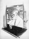
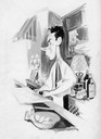
| Date: | 1932 |
|---|---|
| Description: | George bartending at the Irish Veteran's Association. |

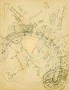
| Date: | 1780 |
|---|---|
| Description: | Hand-drawn plan for the layout of the town of Clarksville, bordering Mayfield Creek and Liberty Creek. Fort Jefferson is shown between the townsite and the... |

| Date: | 1780 |
|---|---|
| Description: | Plan for layout of 150,00 acres which make up Clark's Illinois Grant. |
| Date: | |
|---|---|
| Description: | Site plan pencil sketch of the Neuroseum Hospital, to be located in Madison, Wisconsin, drawn by Frank Lloyd Wright. |
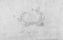
| Date: | |
|---|---|
| Description: | Pencil sketch of Chandler citrus workers camp designed by Frank Lloyd Wright. |

| Date: | 1855 |
|---|---|
| Description: | Detail from a lithograph vignette on a Map of the City of Madison of the third Wisconsin State Capitol, the first Capitol in Madison. |
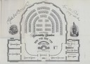
| Date: | 1874 |
|---|---|
| Description: | Seating chart for members of the Wisconsin Assembly as published in the 1874 Legislative Manual, the Wisconsin Blue Book. |

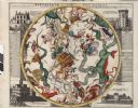
| Date: | 1745 |
|---|---|
| Description: | Zodiac as seen from the Northern Hemisphere. |
| Date: | 1745 |
|---|---|
| Description: | Zodiac as seen from the Southern Hemisphere. |

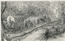
| Date: | 02 21 1874 |
|---|---|
| Description: | African American boatmen run a rapids in a small river boat. |
| Date: | 1948 |
|---|---|
| Description: | Pencil drawing of men building a corderoy road in the 1860's. Used for historical display for the Wisconsin State Highway Department. |

| Date: | 1832 |
|---|---|
| Description: | Hand-drawn map in two parts of the route of Governor J.D. Doty. Probably made by Doty in 1832 as a result of his travels with Alexander J. Center. |
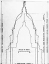
| Date: | |
|---|---|
| Description: | Drawing comparing the dimensions of two Wisconsin State Capitols and the United States Capitol. |
If you didn't find the material you searched for, our Library Reference Staff can help.
Call our reference desk at 608-264-6535 or email us at: