Filter: Categories of Wisconsin Historical Images
Filter: FORMAT_TYPE of photographic print, b
Filter: County of Brown
Filter: Subject of land
Filter: Categories of Wisconsin Historical Images
Filter: FORMAT_TYPE of photographic print, b
Filter: County of Brown
Filter: Subject of land

| Date: | 1867 |
|---|---|
| Description: | Bird's-eye map of Green Bay and Fort Howard, Brown Co., depicts street names and street layouts, houses, trees, and the East River. A reference key at the ... |

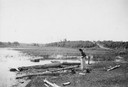
| Date: | 1900 |
|---|---|
| Description: | Elevated view down hill of the Fox River and the Little Rapids dam. |
| Date: | 1900 |
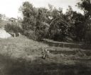
|---|---|
| Description: | A woman stands in a marsh near the site of Eleazer William's first house. |

| Date: | 1953 |
|---|---|
| Description: | Captain John Cotton residence. Also known as "Beaupre," this Greek Revival style house was built in 1842 for Cotton, a retired U.S. Army officer. |

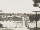
| Date: | |
|---|---|
| Description: | Aerial view of a train crossing the East River in a rural community south of Green Bay. Some buildings are visible to the right and the background of the i... |
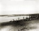
| Date: | 1927 |
|---|---|
| Description: | View down hill towards the Fox River from the Eleazer Williams home. A group of people are automobiles are near a road near the shoreline. |

| Date: | 1905 |
|---|---|
| Description: | Long Tail Lighthouse and surrounding buildings. |
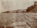
| Date: | |
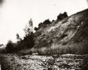
|---|---|
| Description: | View of the shoreline, with a steep embankment. |
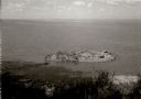
| Date: | 1963 |
|---|---|
| Description: | Elevated view of a small island near the Green Bay shore. |
| Date: | 1908 |
|---|---|
| Description: | Looking down hill southeast across the Fox River bridge. Industrial buildings line the shoreline on the far side. |
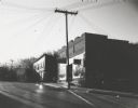
| Date: | 1963 |
|---|---|
| Description: | Street view at sunrise, looking uphill towards commercial buildings. |

| Date: | 1910 |
|---|---|
| Description: | Photographic postcard of elevated view of the Wilcox Stone Mill, and part of Broadway showing the rear view of B.F. Smith's store below the hand-drawn arro... |

| Date: | 1917 |
|---|---|
| Description: | View over the wing of a Lawson Military Tractor 2 (MT2) in flight. Below are houses and what may be a river or lake. Location is unknown, but is probably n... |

| Date: | 1917 |
|---|---|
| Description: | Photographic postcard of a view under the wing of a Lawson Military Tractor 2 (MT2) in flight. Below is a field and beyond are buildings and a body of wate... |

| Date: | 1917 |
|---|---|
| Description: | Photographic postcard showing of a view behind the wing of a Lawson Military Tractor 2 (MT2). Below are fields and in the distance are houses. The photogra... |
| Date: | 1908 |
|---|---|
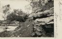
| Description: | View of a stone ledge rock formation. Caption reads: "The Ledge, Greenleaf, Wis." |

| Date: | 1979 |
|---|---|
| Description: | The sun is peeking through the clouds and trees. Snow covers an open field and in the distance is a tree covered hill. |

| Date: | 1818 |
|---|---|
| Description: | Overhead view of the layout of the fort, with the Fox River at the top, and a "Cranberry Marsh of 1/2 mile in extent" below right. At the bottom is a rende... |
If you didn't find the material you searched for, our Library Reference Staff can help.
Call our reference desk at 608-264-6535 or email us at: