Filter: Categories of Wisconsin Historical Images
Filter: FORMAT_TYPE of photographic print, b
Filter: County of Brown
Filter: Subject of transportation
Filter: Subject of botany
Filter: Categories of Wisconsin Historical Images
Filter: FORMAT_TYPE of photographic print, b
Filter: County of Brown
Filter: Subject of transportation
Filter: Subject of botany

| Date: | 1867 |
|---|---|
| Description: | Bird's-eye map of Green Bay and Fort Howard, Brown Co., depicts street names and street layouts, houses, trees, and the East River. A reference key at the ... |
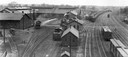
| Date: | 1930 |
|---|---|
| Description: | Elevated view of the Green Bay & Western Railroad roundhouse. |
| Date: | 1930 |
|---|---|
| Description: | Elevated view of the Chicago, Milwaukee & St. Paul Railway yard and roundhouse (left) on South Oakland Avenue. |

| Date: | 1930 |
|---|---|
| Description: | Elevated view of the bridge over the Fox river, and the Nicolet Paper Company on the far shoreline. |

| Date: | 1890 |
|---|---|
| Description: | Congregational Church at the corner of Broadway and Cass Street, with the entrance at the corner. The church has stained glass windows and a steeple. |
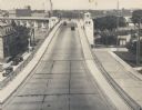
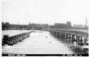
| Date: | 1935 |
|---|---|
| Description: | Elevated view of the bridge, with several cars driving on it. On the left and right are streets below the bridge. In the distance are smokestacks and water... |
| Date: | 1930 |
|---|---|
| Description: | View of a residential neighborhood. Caption reads: "North Broadway on W 41, De Pere, Wis." |
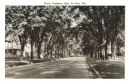
| Date: | 1930 |
|---|---|
| Description: | View of residential street with many trees lining the terrace. Rails, possibly trolley rails, run down the center of the street. Caption reads: "North Broa... |

| Date: | |
|---|---|
| Description: | View down a curving residential, tree-lined street. Trolley tracks run the length of the street. |

| Date: | 1950 |
|---|---|
| Description: | Caption reads: "Looking West on Main Ave." View down center of commercial area, with automobiles moving down the street, and parked along the curbs. A U.S.... |
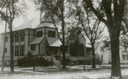
| Date: | 1910 |
|---|---|
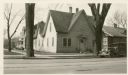
| Description: | Caption reads: Presbyterian Church East De Pere." View from street of the church on a corner. |
| Date: | 1940 |
|---|---|
| Description: | Replica of Eleazer William's original log cabin, with trees and a dirt road, five miles south of De Pere on the west bank of the Fox River. |
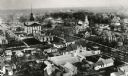
| Date: | 1890 |
|---|---|
| Description: | Aerial view of downtown Green Bay, with the old Court House. |
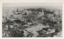
| Date: | 1890 |
|---|---|
| Description: | Aerial view of downtown Green Bay with old Court House and the surrounding buildings. |
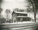
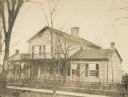
| Date: | 1895 |
|---|---|
| Description: | Winter view across road towards the Baker house, the residence of James S. Baker. |
| Date: | |
|---|---|
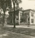
| Description: | Exterior of the Israel Greene Beaumont House, located at 203 South Jefferson Street. The building was demolished in 1932. |
| Date: | 1920 |
|---|---|
| Description: | Exterior view from street towards the Chappel house. |
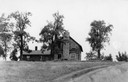
| Date: | |
|---|---|
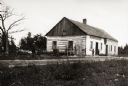
| Description: | Log house located at the top of Collard's Hill. Two children are standing near the house. |
If you didn't find the material you searched for, our Library Reference Staff can help.
Call our reference desk at 608-264-6535 or email us at: