 Filter: Categories of Wisconsin Historical Images
Filter: FORMAT_TYPE of photographic print, b
Filter: Subject of botany
Filter: Subject of bridges
Filter: Categories of Wisconsin Historical Images
Filter: FORMAT_TYPE of photographic print, b
Filter: Subject of botany
Filter: Subject of bridges
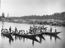
| Date: | 1900 |
|---|---|
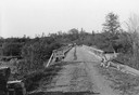
| Description: | Log driving crew on river in five bateaux. In the background on the left is a bridge. |

| Date: | 01 1934 |
|---|---|
| Description: | Aerial view of New Butler, in Waukesha County. |
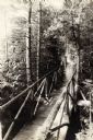
| Date: | 1915 |
|---|---|
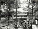
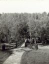
| Description: | Boardwalk bridge through the woods leading to Lake Superior from Coole Park Manor. |

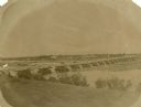
| Date: | 1905 |
|---|---|
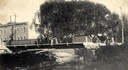
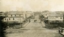
| Description: | Elevated view of Soldiers' Grove with a bridge in the foreground. |
| Date: | 1870 |
|---|---|
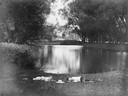
| Description: | View from shoreline over river towards the town. |
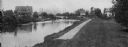
| Date: | 1908 |
|---|---|
| Description: | A view of the Yahara River below Williamson Street. |
| Date: | 1917 |
|---|---|
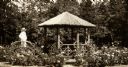
| Description: | Log-constructed gazebo and person on bridge in rose garden. |
| Date: | 06 01 1936 |
|---|---|
| Description: | Bridge and truck trail constructed by Works Progress Administration (WPA) workmen to facilitate forest fire prevention and control. |
| Date: | 1940 |
|---|---|
| Description: | People on a rustic bridge over river at Copper Falls State Park. A long log building is in the background on the other side of the river. |
| Date: | |
|---|---|
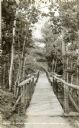
| Description: | View looking down a rustic bridge at Copper Falls State Park. There are benches built into the bridge. |
| Date: | |
|---|---|
| Description: | Two people on a rustic bridge over Bad River at Copper Falls State Park. |
| Date: | |
|---|---|
| Description: | Two boys lying on the grass asleep in Tenney Park near the lagoon with a hat on the ground between them. The Sherman Avenue bridge and the Hausmann Brewery... |
| Date: | 1904 |
|---|---|
| Description: | View across Yahara River towards a group of people on the Sherman Avenue Bridge, with the old malt house in the background. |

| Date: | 1867 |
|---|---|
| Description: | Bird's-eye map of Green Bay and Fort Howard, Brown Co., depicts street names and street layouts, houses, trees, and the East River. A reference key at the ... |
| Date: | 1910 |
|---|---|
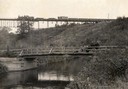
| Description: | View from shoreline of a railroad train crossing a bridge over the famous White River near Ashland. In the foreground is an open automobile crossing the ri... |
| Date: | |
|---|---|
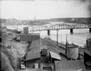
| Description: | Elevated view of the riverfront, railroad tracks, and river, "as viewed from Joseph McGuire's." |
| Date: | 1895 |
|---|---|
| Description: | Elevated view down Main Street, which crosses railroad tracks in the foreground. There are two signs in the foreground which say: "Look Out for the Cars" a... |
| Date: | 1877 |
|---|---|
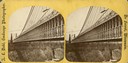
| Description: | An A.L. Dahl photograph, one of "Two different side views of the Suspension Bridge," from the series "Niagara Falls and Suspension Bridge" as mentioned in ... |
| Date: | 1877 |
|---|---|
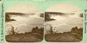
| Description: | An A.L. Dahl photograph, one of "Two different views of the Falls from Canada side," from the series "Niagara Falls and Suspension Bridge" as mentioned in ... |

| Date: | 1930 |
|---|---|
| Description: | Aerial view of the city and the river. |
If you didn't find the material you searched for, our Library Reference Staff can help.
Call our reference desk at 608-264-6535 or email us at: