 Filter: Categories of Wisconsin Historical Images
Filter: FORMAT_TYPE of photographic print, color
Filter: Type of Photograph
Filter: Creator Name of Unknown
Filter: Categories of Wisconsin Historical Images
Filter: FORMAT_TYPE of photographic print, color
Filter: Type of Photograph
Filter: Creator Name of Unknown

| Date: | 04 1959 |
|---|---|
| Description: | The Mississippi River Logging Company's dam built in Soft Maple Creek in 1877. |
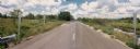
| Date: | |
|---|---|
| Description: | Windshield view of rural County Line Road near Marshfield in Wood County. |

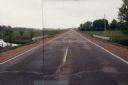
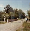
| Date: | 06 1980 |
|---|---|
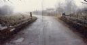
| Description: | Identified only as the intersection of Flowage Road and State Highway 173 in Juneau County, this image probably shows the entrance to the Meadow Valley Flo... |
| Date: | 07 20 1988 |
|---|---|
| Description: | Panoramic view from the Big Sandy Creek Bridge, looking north on Marathon County Highway Q. |
| Date: | 07 20 1988 |
|---|---|
| Description: | Lincoln Drive Bridge in the Town of Berlin, Marathon County. The road in the foreground is not paved, and to the left is a red barn. |

| Date: | 03 16 1984 |
|---|---|
| Description: | A wintertime panoramic view of the bridge on Rainbow Drive, a local road in the Town of Halsey, Marathon County, looking east. |
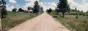
| Date: | 10 30 1987 |
|---|---|
| Description: | Panoramic view of 28th Avenue winding through the Town of Maine in Marathon County. |

| Date: | 03 03 1988 |
|---|---|
| Description: | View from bridge over Wild Creek on Marathon County Highway M. The creek appears frozen, although in flood. Several farms can be seen in the distance. |

| Date: | 04 07 1988 |
|---|---|
| Description: | Panoramic view over Juneau County Highway Q, about four miles south of the entrance to Buckhorn State Park. |
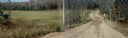
| Date: | 11 01 1982 |
|---|---|
| Description: | Elm Valley Road Bridge over a branch of the Little Wolf River. In the distance, a red barn can be seen through the fog. In the middle distance a member of... |
| Date: | 10 26 1986 |
|---|---|
| Description: | Green Elm Road Bridge over the east fork of Hemlock Creek, showing the rocks used to prevent erosion. |
| Date: | 05 02 1985 |
|---|---|
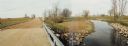
| Description: | Bridge over Duck Creek in the Town of Adams, Adams County, Wisconsin. |
| Date: | 05 02 1985 |
|---|---|
| Description: | Bridge over White Creek in the Town of Easton, Adams County, Wisconsin. |

| Date: | 03 20 1985 |
|---|---|
| Description: | Green Lake CTH FF with a barn and a farmhouse in the distance, a mobile home, and an abandoned log cabin. A closer view of the log cabin can be seen in Ima... |

| Date: | 03 20 1985 |
|---|---|
| Description: | Log cabin on Green Lake County Highway FF, also seen in Image 36120. |

| Date: | 03 20 1985 |
|---|---|
| Description: | A barn located on Green Lake CTH FF near Belle Fountain Creek partially destroyed by fire reaving its method of construction. This structure was located im... |

| Date: | 09 13 1983 |
|---|---|
| Description: | Farm located on Green Lake County highway FF near Belle Fountain Creek. This image shows the log cabin also seen in Image #36120 & #36121, and the barn in... |

| Date: | 11 05 1986 |
|---|---|
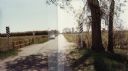
| Description: | Green Lake County Highway M meandering toward a red barn in the distance on a November day, an archtypal Wisconsin landscape. |
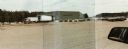
| Date: | 03 21 1986 |
|---|---|
| Description: | Office and metal warehouse of Potato World, Inc., located on County Highway E near Grand Marsh in Adams County. |
| Date: | |
|---|---|
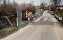
| Description: | Bridge over the Yellow River on County Highway BB in Wood County. |
If you didn't find the material you searched for, our Library Reference Staff can help.
Call our reference desk at 608-264-6535 or email us at: