 Filter: Categories of Wisconsin Historical Images
Filter: FORMAT_TYPE of prints, photomechanical
Filter: Community of Baraboo
Filter: Subject of rivers
Filter: Categories of Wisconsin Historical Images
Filter: FORMAT_TYPE of prints, photomechanical
Filter: Community of Baraboo
Filter: Subject of rivers

| Date: | 1870 |
|---|---|
| Description: | Baraboo was first settled around 1838, and by 1870 it had become the county seat and the thriving village illustrated here. This birds eye drawing depicts ... |
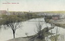
| Date: | |
|---|---|
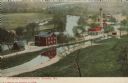
| Description: | Elevated view of the Baraboo River towards a bridge, water tower, and the town beyond. Caption reads: "Baraboo River, Baraboo, Wis." |
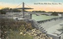
| Date: | 1914 |
|---|---|
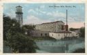
| Description: | Slightly elevated view of the dam, with a bridge in the background. Caption reads: "Island Wollen Mills Dam, Baraboo, Wis." |

| Date: | 1950 |
|---|---|
| Description: | Map showing buildings formerly used as Ringling Brothers Circus winter quarters, along with adjoining buildings. |

| Date: | |
|---|---|
| Description: | Map of Baraboo and its surroundings, showing the ancient mound city, the water power, and thoroughfares, drawn by William H. Canfield. Canfield includes sk... |

| Date: | 1915 |
|---|---|
| Description: | This 1915 map covers the section of the Wisconsin River in southern Adams, southeastern Juneau, northeastern Sauk, and northwestern Columbia counties. A po... |

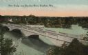
| Date: | 1915 |
|---|---|
| Description: | Colorized postcard view of a bridge over a dam on a river. Trees are along both banks. Caption reads: "The High Bridge and Dam, Baraboo, Wis." |
| Date: | 1919 |
|---|---|
| Description: | Colorized postcard of an elevated view of a concrete bridge over a river. There is a boat near wooden pilings that stretch from the shoreline to the center... |
| Date: | 1938 |
|---|---|
| Description: | Colorized postcard view from shoreline of a stone bridge lined with lampposts. Dwellings and commercial buildings are on the far side. An elevated railroad... |
| Date: | 1908 |
|---|---|
| Description: | Colorized postcard with an elevated view of the pumping station. On the left is a bridge over the river, and buildings on a strip of land between the river... |
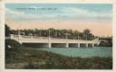
| Date: | 1921 |
|---|---|
| Description: | Colorized postcard view of the exterior of the woolen mill along the banks of a river. A water tower is on the left, and a smokestack is on the right. Capt... |
| Date: | 1972 |
|---|---|
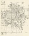
| Description: | This map shows plat of the city, city limits, local streets, and part of the Baraboo River. The map includes 3 inset maps. |

| Date: | 1975 |
|---|---|
| Description: | This map shows plat of the city, city limits, local streets, and part of Baraboo River. The map includes 2 inset maps and a legend showing residential, bus... |

| Date: | 11 28 1908 |
|---|---|
| Description: | Text on front reads: "High Bridge, Baraboo, Wis." A truss bridge over the Baraboo River with a spillway underneath. The shorelines are wooded and buildings... |

| Date: | 08 25 1910 |
|---|---|
| Description: | Text on front reads: "Baraboo, Wis. Boat Landing, Baraboo River." A man in a boat on the river, trees, cottages and piers are on the shorelines. Text on re... |
If you didn't find the material you searched for, our Library Reference Staff can help.
Call our reference desk at 608-264-6535 or email us at: