Filter: Categories of Wisconsin Historical Images
Filter: FORMAT_TYPE of prints, photomechanical
Filter: County of Fond du Lac
Filter: Year of 1800-1899
Filter: Categories of Wisconsin Historical Images
Filter: FORMAT_TYPE of prints, photomechanical
Filter: County of Fond du Lac
Filter: Year of 1800-1899

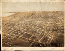
| Date: | 1867 |
|---|---|
| Description: | Birds eye drawing of Fond du Lac depicts street names and street layouts, houses, buildings, trees, and the Fond du Lac River. A reference key at the botto... |

| Date: | 1867 |
|---|---|
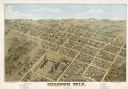
| Description: | Bird's-eye map of Ripon, with insets of points of interest. |

| Date: | 1885 |
|---|---|
| Description: | Bird's-eye map of Waupun on the Rock River. There is an inset at top center of "Althouse, Wheeler & Co., Windmills and Pumps." |

| Date: | 1837 |
|---|---|
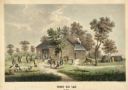
| Description: | Fond du Lac Company House, built in 1836 and operated as an inn by Colwert Pier and his wife. Groups of Indians are in the yard outside the inn, and severa... |
| Date: | 1837 |
|---|---|
| Description: | Fond du Lac Company House. Groups of Indians are in the yard outside the inn, and several Indian dwellings are erected next to it. A man on horseback with ... |

| Date: | 1848 |
|---|---|
| Description: | Foldout map of a sketch of the town grid of Calumet. |

| Date: | 1857 |
|---|---|
| Description: | A quarter section of a map of the city of Fond du Lac. This section features an illustration of Amory Hall and the Exchange Bank of Darling & Co. |

| Date: | 1857 |
|---|---|
| Description: | A quarter section of a map of the City of Fond du Lac featuring the Empire Branch Plank Road. |

| Date: | 1857 |
|---|---|
| Description: | Quarter section of a map of the city of Fond du Lac featuring the Waupun Plank Road. |

| Date: | 1857 |
|---|---|
| Description: | Quarter section of a map of the city of Fond du Lac featuring an illustration of the Lewis House. |
| Date: | 1854 |
|---|---|
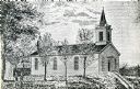
| Description: | Exterior view of a First Congregational Church. |
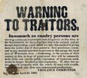
| Date: | 04 21 1861 |
|---|---|
| Description: | "Warning to Traitors." A threatening handbill warning against treasonable and dangerous utterances, signed by the "Vigilance Committee." |

| Date: | 1862 |
|---|---|
| Description: | This map shows townships and sections, landownership and acreages, roads, railroads, cemeteries, churches, schools, mills, and stone quarries. "Engraved, p... |

| Date: | 1840 |
|---|---|
| Description: | Shows plat of town, local streets, Fond du Lac River, and part of Lake Winnebago. |
| Date: | 1867 |
|---|---|
| Description: | Bird’s-eye view map. Indexed for points of interest. |

| Date: | 1874 |
|---|---|
| Description: | Includes index to key buildings. Shows local streets, railroads, fairgrounds, mills, schools, churches, and part of Lake Winnebago. Streets running west to... |

| Date: | 1800 |
|---|---|
| Description: | Shows plat of town, land ownership by name, local streets, courthouses, churches, hotels, mills, railroads, railroad stations, lakes, and rivers. Includes ... |
If you didn't find the material you searched for, our Library Reference Staff can help.
Call our reference desk at 608-264-6535 or email us at: