Filter: Categories of Wisconsin Historical Images
Filter: FORMAT_TYPE of prints, photomechanical
Filter: County of La Crosse
Filter: Subject of dwellings
Filter: Categories of Wisconsin Historical Images
Filter: FORMAT_TYPE of prints, photomechanical
Filter: County of La Crosse
Filter: Subject of dwellings

| Date: | 1867 |
|---|---|
| Description: | Bird's-eye map of La Crosse with nine insets of residences, schools, and the Court House and Jail. |
| Date: | 1908 |
|---|---|
| Description: | View across street toward the Cameron House. A group of people are near the entrance. Caption reads: "Cameron House, La Crosse, Wis." |
| Date: | 1910 |
|---|---|
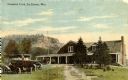
| Description: | View up dirt road toward club. Automobiles are parked on the left. There is a bluff in the background. Caption reads: "Country Club, La Crosse, Wis." |
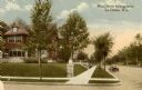
| Date: | 1909 |
|---|---|
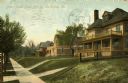
| Description: | Residential homes on the right side of South 15th Street. Caption reads: "Street Scene, South 15th St., La Crosse, Wis." |
| Date: | 1901 |
|---|---|
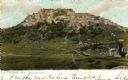
| Description: | Grand Dad Bluff in La Crosse with the Crusher building which was built in 1901 and burned in 1902. Caption reads: "Grand Dad Bluff, La Crosse, Wis." |
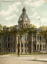
| Date: | 1929 |
|---|---|
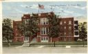
| Description: | View across street toward the hospital. Caption reads: "Grand View Hospital, La Crosse, Wis." |
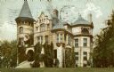
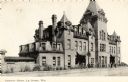
| Date: | 1905 |
|---|---|
| Description: | View across lawn toward the manion. Caption reads: "The Holway Mansion, La Crosse, Wis." |
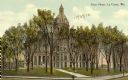
| Date: | 1916 |
|---|---|
| Description: | View across street looking west from 15th Street towards houses on the left side. Caption reads: "Main Street looking west, La Crosse, Wis." |
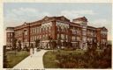
| Date: | 1910 |
|---|---|
| Description: | The State Teacher's College. Caption reads: "State Normal School, La Crosse, Wis." |

| Date: | |
|---|---|
| Description: | Hand-colored exterior view of chapel. Caption reads: "St. Rose Chapel, La Crosse, Wis." |

| Date: | 1857 |
|---|---|
| Description: | Map of La Crosse County, Wisconsin showing village plat, farm houses, schools, roads, railroads, township names (New Amsterdam, Dacota, Minnesota, Driesbac... |

| Date: | 1910 |
|---|---|
| Description: | Map is a blueline print. Map shows United States postal routes for La Crosse County. A list of stations include: Bangor R R 1-3, Holmen R R 1-2, La Crosse ... |

| Date: | |
|---|---|
| Description: | Photographic postcard view down a tree-lined street in a residential neighborhood. Caption reads: "Burns Street, Bangor, Wis." |
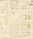
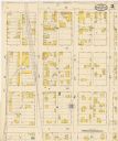
| Date: | 05 1894 |
|---|---|
| Description: | Sheet 2 of an Onalaska Sanborn map, including 2nd, 3rd, and 4th Streets. |

| Date: | 1895 |
|---|---|
| Description: | An illustration in the John A. Salzer's Seed Company catalog advertising varieties of berry seeds. The illustration features raspberries, blackberries, and... |

| Date: | 1898 |
|---|---|
| Description: | The back cover design of the John A. Salzer Seed Company catalog. The illustration features strawberries, tomatotos, and figs, and a woman and girl in a ga... |
If you didn't find the material you searched for, our Library Reference Staff can help.
Call our reference desk at 608-264-6535 or email us at: