Filter: Categories of Wisconsin Historical Images
Filter: FORMAT_TYPE of prints, photomechanical
Filter: County of Rock
Filter: Year of 1800-1899
Filter: Categories of Wisconsin Historical Images
Filter: FORMAT_TYPE of prints, photomechanical
Filter: County of Rock
Filter: Year of 1800-1899

| Date: | 1874 |
|---|---|
| Description: | Bird's-eye view of Beloit, with insets of Beloit College, Beloit High School, and Memorial Hall. |

| Date: | 1877 |
|---|---|
| Description: | Bird's-eye map of Janesville on the Rock River. |

| Date: | 1881 |
|---|---|
| Description: | Bird's-eye map of Milton Junction. |
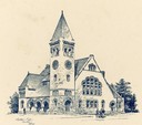
| Date: | 1895 |
|---|---|
| Description: | Drawing of the Edward Dwight Eaton Chapel at Beloit College. |
| Date: | 1865 |
|---|---|
| Description: | The Institution for the Education of the Blind. Caption reads: "Institution for the Education of the Blind, Janesville, Wisc. Free to Blind Children of Wis... |
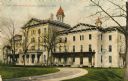
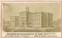
| Date: | 1870 |
|---|---|
| Description: | The State Institute for the Blind, a school free for blind children of Wisconsin. Caption reads: "State Institute for Blind, Janesville, Wis." |
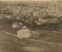
| Date: | 1860 |
|---|---|
| Description: | View from the cupola of the old Jefferson School. The large building in the upper left is the Hyatt House, which burned in 1867. |
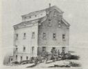
| Date: | 1858 |
|---|---|
| Description: | Drawing of the exterior of the Shopiere Flouring Mill. Several men, some in a horse-drawn wagon are in front of the building. |

| Date: | 1858 |
|---|---|
| Description: | This 1858 map of Rock County, Wisconsin, shows the township and range grid, towns, sections, cities and villages, railroads, roads, property owners and res... |

| Date: | 1853 |
|---|---|
| Description: | Map covers area between the cities of Janesville and Kenosha in Rock, Walworth, and Kenosha counties for railroad routes. Lakes and counties are labelled. ... |
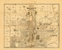
| Date: | 1887 |
|---|---|
| Description: | This map of Beloit shows labeled wards, plat of town, roads, railroads, the Rock River, city boundaries, and land ownership by name. The back of the map is... |

| Date: | 1860 |
|---|---|
| Description: | Map showing a plat of the city, land ownership by name, wards by number, local streets, buildings, fair grounds, nurseries, and part of Rock River. The map... |

| Date: | 1873 |
|---|---|
| Description: | This map shows landownership and acreages, lot and block numbers, roads and railroads, marshes, schools, churches, mills, rural buildings, and quarries. Re... |

| Date: | 1850 |
|---|---|
| Description: | This map shows a plat of the town, land owners by name, local streets, railroads, churches, and part of the Rock River. The map is also indexed by church d... |

| Date: | 1873 |
|---|---|
| Description: | This map shows land ownership by name, local streets, railroads, parks, college grounds, schools, cemeteries, and part of Rock River. The upper left margin... |
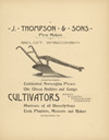
| Date: | 1860 |
|---|---|
| Description: | Advertisement for plows, cultivators, harrows, corn planters, mowers, rakes, sulkies and gangs. |
If you didn't find the material you searched for, our Library Reference Staff can help.
Call our reference desk at 608-264-6535 or email us at: