 Filter: Categories of Wisconsin Historical Images
Filter: FORMAT_TYPE of prints, photomechanical
Filter: Subject of arts
Filter: Subject of cemeteries
Filter: Categories of Wisconsin Historical Images
Filter: FORMAT_TYPE of prints, photomechanical
Filter: Subject of arts
Filter: Subject of cemeteries
| Date: | |
|---|---|
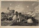
| Description: | Engraving excerpted from John S.C. Abbott's History of the Civil War in America. |
| Date: | |
|---|---|
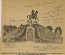
| Description: | Drawing of a monument to General Albert Sydney Johnston, which was erected by Association of the Army of Tennessee in the St. Louis Cemetery in New Orleans... |

| Date: | |
|---|---|
| Description: | This 1907 map of Outagamie County, Wisconsin, shows the township and range grid, towns, sections, cities and villages, railroads, wagon roads, churches, sc... |

| Date: | 1970 |
|---|---|
| Description: | This map shows lot and block numbers, city limits, cemeteries, schools, outdoor theater, Lumberjack Bowl, and Historyland among other attractions. |

| Date: | 1791 |
|---|---|
| Description: | Small map of an abandoned Native American town and fort at the junction of the Ohio and Muskingum River. It shows the fortifications, an outline of the tow... |
| Date: | |
|---|---|
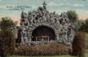
| Description: | Hand-colored view of the grotto in the Catholic Cemetery. Caption reads: "Grotto — Catholic Cemetery, La Crosse, Wis." |
If you didn't find the material you searched for, our Library Reference Staff can help.
Call our reference desk at 608-264-6535 or email us at: