 Filter: Categories of Wisconsin Historical Images
Filter: FORMAT_TYPE of prints, photomechanical
Filter: Subject of battles
Filter: Subject of dwellings
Filter: Categories of Wisconsin Historical Images
Filter: FORMAT_TYPE of prints, photomechanical
Filter: Subject of battles
Filter: Subject of dwellings
| Date: | 1888 |
|---|---|
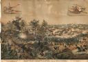
| Description: | Lithographed advertising poster showing the Civil War Battle of Atlanta. Produced for the McCormick Harvesting Machine Company, the poster features insets ... |

| Date: | 1943 |
|---|---|
| Description: | Treasury Design No. 24, "Happy Family." The poster features two contrasting scenes. On the left is a naval battle commencing on stormy waters in shades of ... |
| Date: | 08 1862 |
|---|---|
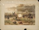
| Description: | Color lithograph of Union lines in the midst of battle. |
| Date: | |
|---|---|
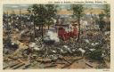
| Description: | Color postcard of a section of the cyclorama painting "Battle of Atlanta" executed by painters under Wilhem Wehner in the 1880s. This scene shows the fight... |

| Date: | 1863 |
|---|---|
| Description: | These detailed topographical maps of the Battle of Gettysburg show drainage, vegetation, roads, railroads, fences, houses with names of residents, and a de... |

| Date: | 1863 |
|---|---|
| Description: | These detailed topographical maps of the Battle of Gettysburg show drainage, vegetation, roads, railroads, fences, houses with names of residents, and a de... |

| Date: | 1863 |
|---|---|
| Description: | This map shows drainage, vegetation, roads, railroads, fences, dwellings with names of inhabitants, and land owned by the United States. Union and Confeder... |

| Date: | 1864 |
|---|---|
| Description: | This map depicts the positions of Union forces, in blue, and Confederate forces, in red, at the end of 1863 after the cessation of the Knoxville Campaign. ... |

| Date: | 1864 |
|---|---|
| Description: | This map of the area of the First Battle of Bull Run shows military positions and troop movements as well as the names of landowners, vegetation and land u... |

| Date: | 1865 |
|---|---|
| Description: | This detailed map of the area between Richmond and Petersburg shows fortifications, roads, railroads, towns, street patterns of Petersburg and Richmond, dr... |

| Date: | 1866 |
|---|---|
| Description: | This detailed map shows the positions of the armies of the Ohio and Tennessee, Confederate lines, headquarters, "regimental camps at the date of the battle... |

| Date: | |
|---|---|
| Description: | Pen and ink tracing showing the positions of Union and Confederate soldiers, troop camps, location of graves, roads, drainage, vegetation, houses, and fenc... |

| Date: | 1865 |
|---|---|
| Description: | The map of the battlefield shows entrenchments, villages, roads, the "South Side Rail Road" drainage, vegetation, relief by hachures, houses, and names of ... |

| Date: | |
|---|---|
| Description: | This detailed map shows fortifications, headquarters, location and dates of battles, street outline of Atlanta, roads, railroads, vegetation, drainage, rel... |

| Date: | 1862 |
|---|---|
| Description: | This detailed map shows batteries and rifle pits, railroads, common and military roads, turnpikes, city streets and names, bridges, ferries, rural houses a... |

| Date: | 01 28 1862 |
|---|---|
| Description: | Letterhead depicting a scene in the Battle of Big Bethel, in which Lieutenant John T. Greble refused to pull back, as he continued to fire his last cannon.... |

| Date: | 1615 |
|---|---|
| Description: | Illustration of the Huron Indians and French explorers attacking an Iroquois fort near present day Fenner, New York. A wooden platform was constructed to f... |
If you didn't find the material you searched for, our Library Reference Staff can help.
Call our reference desk at 608-264-6535 or email us at: