 Filter: Categories of Wisconsin Historical Images
Filter: FORMAT_TYPE of prints, photomechanical
Filter: Subject of bays
Filter: Categories of Wisconsin Historical Images
Filter: FORMAT_TYPE of prints, photomechanical
Filter: Subject of bays

| Date: | 1920 |
|---|---|
| Description: | This map represents around 1841 and shows Lake Superior, other lakes, rivers, bays, and the border between Michigan and Wisconsin. There are annotations in... |
| Date: | 1900 |
|---|---|
| Description: | This map shows the distances and land use and type along the road from Green Bay to Racine. A few places are labeled, including Devil River, Sheboygan Rive... |

| Date: | 1936 |
|---|---|
| Description: | This map shows campsites, trails, auto roads, surrounding townships, and points of interest, by including pictorial illustrations. Includes an inserted map... |
| Date: | |
|---|---|
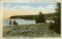
| Description: | Colored postcard view near the extreme northern point of Door County. There is a man standing on the left in a field of flowers looking at the bay. Fishing... |
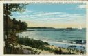
| Date: | 1932 |
|---|---|
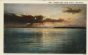
| Description: | Color postcard view of a brilliant sunset over Green Bay. There is a forested shoreline in the distance. Caption reads: "Sunset View, Door County, Wisconsi... |
| Date: | |
|---|---|
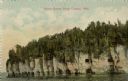
| Description: | View across water towards the bluffs at the northern end of Door County. |
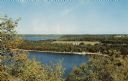
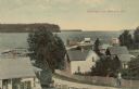
| Date: | 1957 |
|---|---|
| Description: | Elevated view of Little Sister Bay and the surrounding landscape. |

| Date: | 1735 |
|---|---|
| Description: | Map of the Chesapeake Bay region and surrounding areas, with north oriented towards the right. A few forts, rivers, and bays are labeled, as are the region... |
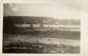
| Date: | 1932 |
|---|---|
| Description: | Colorized postcard of Green Bay from Egg Harbor. A long pier with a rowboat at the side and a sailboat at the end. Caption reads: "Harbor Scene - Alpine Re... |
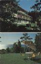
| Date: | |
|---|---|
| Description: | Two views of Egg Harbor Lodge — with the view of the lodge, and of Green Bay. |

| Date: | |
|---|---|
| Description: | Elevated view over trees and Sheboygan Bay towards a row of lakeside dwellings. Caption reads: "Sheboygan Bay, Elkhart Lake, Wis." |

| Date: | 1932 |
|---|---|
| Description: | This map shows automobile routes across Wisconsin and parts of Illinois, Michigan, Minnesota and Iowa. The Mississippi River, Lake Michigan, Lake Superior,... |

| Date: | 1933 |
|---|---|
| Description: | This road map shows automobile routes across Wisconsin as well as portions of Illinois, Minnesota, Iowa and Michigan. Lakes Michigan, Superior and Winnebag... |

| Date: | 1933 |
|---|---|
| Description: | This map contains automobile routes across Wisconsin and portions of Illinois, Iowa, Minnesota and Michigan as well. The state borders are clearly defined... |

| Date: | 1934 |
|---|---|
| Description: | This map provides automobile routes through Wisconsin along with portions of Illinois, Iowa, Minnesota and Michigan. Lake Superior, Lake Michigan, Green B... |

| Date: | 1934 |
|---|---|
| Description: | This road map contains automobile routes for the state of Wisconsin as well as portions of Minnesota, Illinois, Iowa and Michigan. Lake Michigan, Lake Sup... |
| Date: | |
|---|---|
| Description: | View of Beach Road and the beach at Ellison Bay. Buildings are across the bay, and a tree-lined ridge is in the far background. Caption reads: "Beach Road,... |
| Date: | |
|---|---|
| Description: | Elevated view from hill of the bay and Ephraim. A man is walking up the hill on a road with buildings and fences on both sides. Caption reads: "Greetings f... |

| Date: | |
|---|---|
| Description: | Elevated view of Green Bay from Ephraim. There is an island in the bay. Caption reads: "Lake View from Scandinavian Peasant Craft Shop, Ephraim, Wis." |

| Date: | |
|---|---|
| Description: | Drawing of a map showing the cruise routes from Eagle Inn Dock and the points of interest. There is a schedule and rates on the reverse. |
If you didn't find the material you searched for, our Library Reference Staff can help.
Call our reference desk at 608-264-6535 or email us at: