 Filter: Categories of Wisconsin Historical Images
Filter: FORMAT_TYPE of prints, photomechanical
Filter: Subject of breweries
Filter: Subject of manufacturing industries
Filter: Categories of Wisconsin Historical Images
Filter: FORMAT_TYPE of prints, photomechanical
Filter: Subject of breweries
Filter: Subject of manufacturing industries

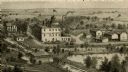
| Date: | 1878 |
|---|---|
| Description: | Bird's-eye map of Chilton with insets of points of interest, including P.H. Becker's Brewery, Chilton House, and Gutheil's Block. |
| Date: | |
|---|---|
| Description: | An engraving based on a drawing by Alexander Simplot of the Platteville Brewery (spelled Plattville). It is an elevated perspective showing the main buildi... |
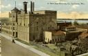
| Date: | 1910 |
|---|---|
| Description: | Elevated view of the brewery with the Mississippi River in the background. Caption reads: "G. Heileman Brewing Co., La Crosse, Wis." |

| Date: | 1905 |
|---|---|
| Description: | Elevated view of the Pabst Brewery shipping yard showing several teams of horses hitched to wagons loaded with barrels of beer. A man holds the reins of ea... |

| Date: | 1955 |
|---|---|
| Description: | Postcard of the Pabst Brewery showing an elevated view of men working near the copper kettles in a vaulted room. There is a large, stained glass window on ... |
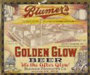
| Date: | 1933 |
|---|---|
| Description: | Label submitted to the State of Wisconsin for trademark registration. "Blumer's Golden Glow Beer, 'It's the After Glow', Blumer Products Co." The center of... |
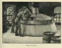
| Date: | 1885 |
|---|---|
| Description: | Engraved image of a man adding ingredients from a barrel to a boiling vat of beer. |

| Date: | 1936 |
|---|---|
| Description: | International C-15 truck owned by J.A. LaFontaine of Amos, Quebec, Canada and used by Carling Breweries. |

| Date: | 1886 |
|---|---|
| Description: | This map has relief shown by hachures and includes a list of plats in order of date of record, laws which vacate plats, plats not shown as upon the county ... |

| Date: | 1883 |
|---|---|
| Description: | This map shows ward boundaries, names of additions, streets, bridges, mills, schools, religious buildings, businesses, hotels, railroads, factories, brewer... |
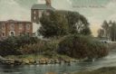
| Date: | 1911 |
|---|---|
| Description: | View from shoreline across river towards an industrial building near the Yahara River. A bridge is behind trees and bushes on the right. Caption reads: "Te... |

| Date: | 1915 |
|---|---|
| Description: | A Sanborn fire insurance map of Sauk City created in 1915. |

| Date: | 1900 |
|---|---|
| Description: | A Sanborn fire insurance map of Sauk City created in 1900. |
If you didn't find the material you searched for, our Library Reference Staff can help.
Call our reference desk at 608-264-6535 or email us at: