 Filter: Categories of Wisconsin Historical Images
Filter: FORMAT_TYPE of prints, photomechanical
Filter: Subject of breweries
Filter: Categories of Wisconsin Historical Images
Filter: FORMAT_TYPE of prints, photomechanical
Filter: Subject of breweries

| Date: | 1984 |
|---|---|
| Description: | Text on reverse reads: "THE STATUE OF GAMBRINUS, the legendary Flemish King, generally referred to as the inventor and King of Beer, is a famous landmark a... |

| Date: | 10 1884 |
|---|---|
| Description: | A Sanborn map of Watertown, including the City Brewery and the Rock River. |

| Date: | 1895 |
|---|---|
| Description: | Composite art page from a booklet of verses about Miller Beer. Images include a woman at top left who is perhaps working with hops, captioned: "Original Mi... |
| Date: | 1911 |
|---|---|
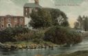
| Description: | View from shoreline across river towards an industrial building near the Yahara River. A bridge is behind trees and bushes on the right. Caption reads: "Te... |

| Date: | 01 01 1910 |
|---|---|
| Description: | Text on front reads: "Interior, Schlitz Palm Garden, Milwaukee." A very ornately decorated space with a barrel vaulted ceiling. Skylights and arched window... |

| Date: | 1910 |
|---|---|
| Description: | Text on front reads: "1125 Cady Street, Watertown, Wis." The William Hartig Brewing Company with the Jacob Hoeffner home on the right. On the unpaved stree... |

| Date: | 1907 |
|---|---|
| Description: | Text on front reads: "C. & N.W. Depot, Waukesha, Wis." The Waukesha Spring Brewery building is on the left and the Chicago & North Western Depot is on the ... |

| Date: | 1907 |
|---|---|
| Description: | Text on front reads: "Showing the Dam of the Milwaukee River, West Bend, Wis." Elevated view of the West Bend dam with a brewery on the left in the backgro... |

| Date: | 1860 |
|---|---|
| Description: | Inset from Map of Dodge County. Caption reads: "Farmer's Brewery, (Beaver Dam) Aman & Schutte, Proprs." A sign on the building reads: "Farmer's Brewery by ... |

| Date: | 1892 |
|---|---|
| Description: | A Sanborn fire insurance map of Sauk City which was drawn up in 1892. |

| Date: | 1915 |
|---|---|
| Description: | A Sanborn fire insurance map of Sauk City created in 1915. |

| Date: | 1900 |
|---|---|
| Description: | A Sanborn fire insurance map of Sauk City created in 1900. |

| Date: | 1891 |
|---|---|
| Description: | The index page of a Sanborn Map of Stevens Point. |

| Date: | 1891 |
|---|---|
| Description: | Page 13 of a Sanborn map of Stevens Point. |
If you didn't find the material you searched for, our Library Reference Staff can help.
Call our reference desk at 608-264-6535 or email us at: