 Filter: Categories of Wisconsin Historical Images
Filter: FORMAT_TYPE of prints, photomechanical
Filter: Subject of bridges
Filter: Subject of hotels
Filter: Categories of Wisconsin Historical Images
Filter: FORMAT_TYPE of prints, photomechanical
Filter: Subject of bridges
Filter: Subject of hotels

| Date: | 1878 |
|---|---|
| Description: | Bird's-eye map of Chilton with insets of points of interest, including P.H. Becker's Brewery, Chilton House, and Gutheil's Block. |

| Date: | 1874 |
|---|---|
| Description: | Bird's-eye view of Waukesha, looking southwest, with insets of State Industrial School, Court House, and Fountain Spring House. |

| Date: | 1905 |
|---|---|
| Description: | View down unpaved road towards a drawbridge in Princeton. There is a hotel on the right. Caption reads: "Draw Bridge at Princeton, Wis." |

| Date: | 1950 |
|---|---|
| Description: | This road map shows federal, state and county roads in Wisconsin, northern Illinois, northeastern Iowa, eastern Minnesota, and the western portion of Michi... |

| Date: | |
|---|---|
| Description: | View across Mississippi River towards the La Crosse waterfront. Postcard is folded in four parts, and text on front reads: "Mail Card. Write on back of thi... |
| Date: | |
|---|---|
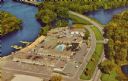
| Description: | Aerial view of the Holiday Inn, between La Crosse on Barron Island in the beautiful Mississippi. A curved road is leading to a bridge across the Mississipp... |

| Date: | 04 01 1905 |
|---|---|
| Description: | Text on front reads: "Sheboygan, Wis. the .......190." The person writing the postcard added the date and year. Four scenes are displayed within Art Nouvea... |
| Date: | 1935 |
|---|---|
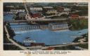
| Description: | Text on front reads: "Bird's-eye View of Riverview Service Group, Looking East, At The Dells, Wisconsin Dells, Wisconsin." On reverse: "All the world knows... |

| Date: | 1904 |
|---|---|
| Description: | Text on front reads: "Old Bridge and Dell House, built in 1837, Wisconsin Dells." The Dell Bridge, first to span the Wisconsin River at the Narrows, was bu... |

| Date: | 1892 |
|---|---|
| Description: | A Sanborn fire insurance map of Sauk City which was drawn up in 1892. |

| Date: | 1915 |
|---|---|
| Description: | A Sanborn fire insurance map of Sauk City created in 1915. |
If you didn't find the material you searched for, our Library Reference Staff can help.
Call our reference desk at 608-264-6535 or email us at:
