 Filter: Categories of Wisconsin Historical Images
Filter: FORMAT_TYPE of prints, photomechanical
Filter: Subject of buildings
Filter: Community of Milwaukee
Filter: Categories of Wisconsin Historical Images
Filter: FORMAT_TYPE of prints, photomechanical
Filter: Subject of buildings
Filter: Community of Milwaukee
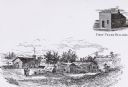
| Date: | 1833 |
|---|---|
| Description: | Illustration of the Solomon Juneau fur trading post at Milwaukee in 1833. |
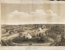
| Date: | 1859 |
|---|---|
| Description: | Elevated view of the fairgrounds in Milwaukee, the year when Abraham Lincoln spoke. The fairgrounds were located at the Brockway Grounds near Twelfth and S... |
| Date: | |
|---|---|
| Description: | View across street towards a red brick building with a flag pole in the yard on the left. A small stone block that reads "Calumet" is on the sidewalk. Capt... |

| Date: | 1905 |
|---|---|
| Description: | View across street toward the Young Men's Christian Association building (YMCA). Caption reads: "Y. M. C. A., Milwaukee, Wis." |

| Date: | 1910 |
|---|---|
| Description: | Elevated view over trees and bushes toward the footbridge. A building with a red roof is on the far right. Beyond the bridge is Lake Michigan. Caption read... |
| Date: | 1908 |
|---|---|
| Description: | A dirt drive in the park, in between some hills, with a bridge in the background leading to a building on the right. Next to the path are a stack of pipes... |

| Date: | 1920 |
|---|---|
| Description: | Elevated view of the building on a street corner, with a flag flying from the roof. The street has parked cars and pedestrians are on the sidewalks. Captio... |
| Date: | 1915 |
|---|---|
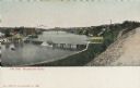
| Description: | Elevated view of dam on river. A bridge is in the background. Houses are on top of the hill on the right side. Caption reads: "The Dam, Milwaukee River." |

| Date: | 1920 |
|---|---|
| Description: | Elevated view of dam with a bridge further up the river. Buildings are along the shoreline and on top of the hill on the right. Caption reads: "Scene Above... |
| Date: | |
|---|---|
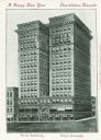
| Description: | View of building. Text in English and German reads: "A Happy New Year" and "Glueckliches Neujahr." Caption at bottom reads: "The Wells Building." and "Well... |
| Date: | |
|---|---|
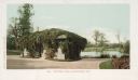
| Description: | Small building covered with vines on the roof and sides on a path near the lake. Caption reads: "Mitchell Park, Milwaukee, Wis." |
| Date: | |
|---|---|
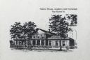
| Description: | Caption reads: "Sisters' House, Academy and Orphanage Van Buren St." Three trees stand in front of the building. A woman is in front left of center, and tw... |

| Date: | 1891 |
|---|---|
| Description: | This maps has an index of depots, hotels, prominent institutions and buildings, churches, and places of amusement. The map was removed from an unidentified... |
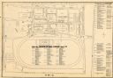
| Date: | 1948 |
|---|---|
| Description: | This map of the Wisconsin Centennial Exposition is oriented with north to the right. The right hand margin includes "Outstanding Events of the Grandstand P... |
| Date: | 1974 |
|---|---|
| Description: | This map of Milwaukee shows forty landmark buildings located and identified, including those on the National Register of Historic Places and the Historic A... |

| Date: | 1893 |
|---|---|
| Description: | This map shows city wards, block numbers, parks, cemeteries, roads, railroads, selected buildings, and Lake Michigan. Also included are indexes to streets,... |

| Date: | 1900 |
|---|---|
| Description: | This map shows city wards, block numbers, parks, cemeteries, roads, railroads, Lake Michigan, and selected buildings. Also included are indexes "Milwaukee ... |

| Date: | 1901 |
|---|---|
| Description: | This map shows city wards, block numbers, parks, cemeteries, roads, railroads, Lake Michigan, and selected buildings. Also included are indexes "Milwaukee ... |

| Date: | 1920 |
|---|---|
| Description: | This map shows wards, streets, railroads, parks, cemeteries, select buildings, and Lake Michigan. Also included is a street index. Cemeteries and parks are... |

| Date: | 1854 |
|---|---|
| Description: | This map shows bay and harbor soundings, the Milwaukee River, and select buildings. Depths are shown by soundings and relief is shown by hachures. The top ... |
If you didn't find the material you searched for, our Library Reference Staff can help.
Call our reference desk at 608-264-6535 or email us at: