 Filter: Categories of Wisconsin Historical Images
Filter: FORMAT_TYPE of prints, photomechanical
Filter: Subject of buildings
Filter: County of Dane
Filter: Categories of Wisconsin Historical Images
Filter: FORMAT_TYPE of prints, photomechanical
Filter: Subject of buildings
Filter: County of Dane

| Date: | 1913 |
|---|---|
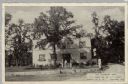
| Description: | Rocky Roost, a cottage, which was located west of Governor's Island in Lake Mendota. The cottage was designed and built in 1893 (according to Taliesin Asso... |
| Date: | 08 24 1971 |
|---|---|
| Description: | A special issue of the Madison Kaleidoscope which features poetry and an article about the bombing of the Army Mathematics Research Center located i... |

| Date: | 1909 |
|---|---|
| Description: | This 1909 bird's-eye view of Madison and the surrounding Four Lakes region shows roads, railroads, selected buildings in Madison, and points of interest ar... |

| Date: | 1929 |
|---|---|
| Description: | This map is oriented with north to the upper right. Includes index of retailers and buildings, with some advertisements in margins. |

| Date: | 1970 |
|---|---|
| Description: | Map features a legend of roads, trails, points of interest, buildings, and types of vegetation. To the right are "ARBORETUM REGULATIONS" regarding hours, p... |
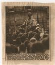
| Date: | 11 26 1963 |
|---|---|
| Description: | Original UPI Wirephoto transmission. Caption reads: "Even the statue of Abraham Lincoln on the University of Wisconsin campus seemed more somber 11/25 than... |

| Date: | 1889 |
|---|---|
| Description: | This map shows a plat of city, city limits, numbered blocks, numbered lots, wards, local streets, roads, railroads, street railways, fire limits, hydrants,... |

| Date: | 1856 |
|---|---|
| Description: | This map is ink and watercolor on tracing paper and shows plat of city, local streets, block numbers, topography, several buildings, and includes an explan... |
| Date: | 1975 |
|---|---|
| Description: | This bird’s-eye-view map is a series of photographs compiled to show local streets and buildings. |

| Date: | 1923 |
|---|---|
| Description: | Pamphlet advertising classes for "foreigners" to learn English at the Neighborhood House. The Neighborhood House is pictured on the pamphlet with a U.S. fl... |

| Date: | 1920 |
|---|---|
| Description: | This hand-colored bird's-eye-view map shows roads, parks, golf club, schools, buildings, landscaping, and part of Lake Wingra. |

| Date: | 1975 |
|---|---|
| Description: | This map shows transportation routes taken by public transit. Includes a key to bus routes, schedule, and transit information. Includes labels for streets,... |

| Date: | |
|---|---|
| Description: | Elevated view of the south east campus area with Lake Monona in the background. |
| Date: | 1954 |
|---|---|
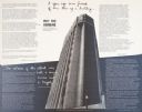
| Description: | The First National Bank building on the corner of South Pinckney Street and East Washington Avenue. |

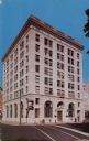
| Date: | |
|---|---|
| Description: | Five-story white stone building in the middle of a city block. Caption reads: "Y. W. C. A., Madison, Wis." |

| Date: | |
|---|---|
| Description: | View across street towards the office of National Mutual Benefit, a seven-story building on a street corner. |
| Date: | 1941 |
|---|---|
| Description: | View across road towards a restaurant/bar located 1 1/2 miles south of the city limit on Hwys 12 & 18. A man is standing on the front steps. There is an el... |

| Date: | 1948 |
|---|---|
| Description: | Three views of the Kennedy Manor Dining Room and Cocktail Lounge: exterior of front of the building, the dining room, and bar area with jukebox. Located at... |
| Date: | 1945 |
|---|---|
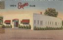
| Description: | Exterior view of a supper club. A white, rectangular building with awnings over the windows, and bushes around the foundation. Caption reads: "Leo's Esquir... |

| Date: | |
|---|---|
| Description: | Aerial view of Capitol Square from above King Street. Caption reads: "Aeroplane View of State Capitol, Madison, Wis." Text on reverse reads: "Constructi... |
If you didn't find the material you searched for, our Library Reference Staff can help.
Call our reference desk at 608-264-6535 or email us at: